
Carte topographique Alston
Carte interactive
Cliquez sur la carte pour afficher l’altitude.
À propos de cette carte
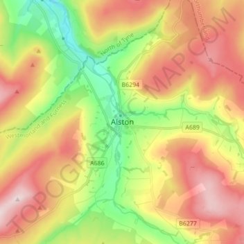
Nom : Carte topographique Alston, altitude, relief.
Altitude moyenne : 404 m
Altitude minimum : 221 m
Altitude maximum : 598 m
Alston is a town in Cumbria, England, within the civil parish of Alston Moor on the River South Tyne. It shares the title of the 'highest market town in England', at about 1,000 feet (300 m) above sea level, with Buxton, Derbyshire. Despite its altitude, the town is easily accessible via the many roads which link the town to Weardale, Teesdale, and towns in Cumbria such as Penrith via Hartside Pass, as well as Tynedale. Historically part of Cumberland, Alston lies within the North Pennines, a designated Area of Outstanding Natural Beauty. Much of the town centre is a designated Conservation Area which includes several listed buildings.
Autres cartes topographiques
Cliquez sur une carte pour visualiser sa topographie, son altitude et son relief.
Brockleymoor
United Kingdom > England > Cumbria > Eden District > Plumpton
Brockleymoor, Hesket, Plumpton, Eden District, Cumbria, England, CA11 9NX, United Kingdom
Altitude moyenne : 155 m
Middleton
United Kingdom > England > Cumbria > Eden District
Middleton, Eden District, Cumbria, England, CA10 3UL, United Kingdom
Altitude moyenne : 407 m
Appleby-in-Westmorland
United Kingdom > England > Cumbria > Eden District
Appleby-in-Westmorland, Eden District, Cumbria, England, United Kingdom
Altitude moyenne : 155 m