
Carte topographique East Port Medway
Carte interactive
Cliquez sur la carte pour afficher l’altitude.
À propos de cette carte
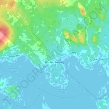
Nom : Carte topographique East Port Medway, altitude, relief.
Altitude moyenne : 15 m
Altitude minimum : -1 m
Altitude maximum : 95 m
Autres cartes topographiques
Cliquez sur une carte pour visualiser sa topographie, son altitude et son relief.
Great Island
Canada > Nova Scotia > Queens County > Port Medway
Great Island, Port Medway, Region of Queens Municipality, Queens County, Nova Scotia, B0J 2T0, Canada
Altitude moyenne : 1 m
Dog Island
Canada > Nova Scotia > Queens County > Mill Village
Dog Island, Mill Village, Region of Queens Municipality, Queens County, Nova Scotia, B0J 2H0, Canada
Altitude moyenne : 4 m