
Carte topographique Lhamo Latso
Carte interactive
Cliquez sur la carte pour afficher l’altitude.
À propos de cette carte
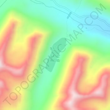
Nom : Carte topographique Lhamo Latso, altitude, relief.
Lieu : Lhamo Latso, Cuijiu, Gyatsa County, Shannan, Tibet, China (29.51270 92.73542 29.52118 92.74139)
Altitude moyenne : 5’104 m
Altitude minimum : 4’811 m
Altitude maximum : 5’473 m
Lhamo Latso... [is] a brilliant azure jewel set in a ring of grey mountains. The elevation and the surrounding peaks combine to give it a highly changeable climate, and the continuous passage of cloud and wind creates a constantly moving pattern on the surface of the waters. On that surface visions appear to those who seek them in the right frame of mind.