
Carte topographique Town of Ossining
Carte interactive
Cliquez sur la carte pour afficher l’altitude.
À propos de cette carte
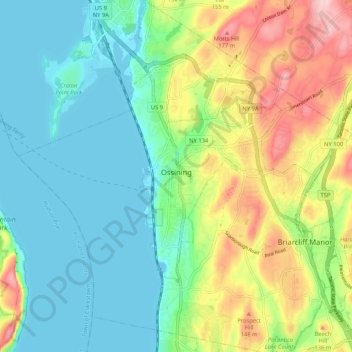
Nom : Carte topographique Town of Ossining, altitude, relief.
Altitude moyenne : 65 m
Altitude minimum : -2 m
Altitude maximum : 201 m
Autres cartes topographiques
Cliquez sur une carte pour visualiser sa topographie, son altitude et son relief.
Village of Ossining
United States > New York > Westchester County > Town of Ossining
Village of Ossining, Town of Ossining, Westchester County, New York, 10562, United States
Altitude moyenne : 61 m
Spring Valley
United States > New York > Westchester County > Town of Ossining > Ossining > Spring Valley
Spring Valley, Ossining, Town of Ossining, Westchester County, New York, 10545, United States
Altitude moyenne : 115 m