
Carte topographique Marvdasht
Carte interactive
Cliquez sur la carte pour afficher l’altitude.
À propos de cette carte
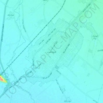
Nom : Carte topographique Marvdasht, altitude, relief.
Altitude moyenne : 1’598 m
Altitude minimum : 1’587 m
Altitude maximum : 1’723 m
Marvdasht is one of the northern cities and also counties of Fars province. The city is located 45 km north of Shiraz and has an altitude of 1620 meters above the sea level. The county has an area of 3687 square kilometers and neighbors Arsenjan in the east, Pasargad in the north, Khorambid and Eghlid in the northwest, Sepidan in the southwest and Shiraz in the south. There are three cities in the county: Marvdasht, Seydan and Kamfirouz. Marvdasht as a county is divided into four districts: Central, Kamfirouz, Doroudzan and Seydan. Marvdasht has a cold weather in the hilly areas and moderate climate in other regions.
Autres cartes topographiques
Cliquez sur une carte pour visualiser sa topographie, son altitude et son relief.
شهر مرودشت
Iran > Fars Province > Marvdasht County > شهر مرودشت
شهر مرودشت, Central District Marvdasht County, Marvdasht County, Fars Province, Iran
Altitude moyenne : 1’598 m