
Carte topographique Hudson
Carte interactive
Cliquez sur la carte pour afficher l’altitude.
À propos de cette carte
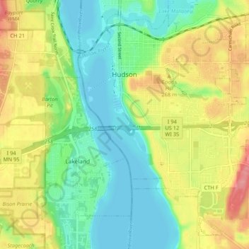
Nom : Carte topographique Hudson, altitude, relief.
Lieu : Hudson, Saint Croix County, Wisconsin, 54016, United States (44.93794 -92.77081 44.98918 -92.68940)
Altitude moyenne : 243 m
Altitude minimum : 204 m
Altitude maximum : 302 m
Autres cartes topographiques
Cliquez sur une carte pour visualiser sa topographie, son altitude et son relief.
Mount Hellen
United States > Wisconsin > Saint Croix County > Town of Saint Joseph
Mount Hellen, Town of Saint Joseph, Saint Croix County, Wisconsin, United States
Altitude moyenne : 282 m
Village of Hammond
United States > Wisconsin > Saint Croix County
Village of Hammond, Saint Croix County, Wisconsin, United States
Altitude moyenne : 342 m
Somerset
United States > Wisconsin > Saint Croix County > Somerset
Somerset, Saint Croix County, Wisconsin, 54025, United States
Altitude moyenne : 273 m
Baldwin
United States > Wisconsin > Saint Croix County > Baldwin
Baldwin, Saint Croix County, Wisconsin, 54002, United States
Altitude moyenne : 350 m
Town of Somerset
United States > Wisconsin > Saint Croix County
Town of Somerset, Saint Croix County, Wisconsin, United States
Altitude moyenne : 279 m
Town of Hudson
United States > Wisconsin > Saint Croix County
Town of Hudson, Saint Croix County, Wisconsin, United States
Altitude moyenne : 281 m
New Richmond
United States > Wisconsin > Saint Croix County
New Richmond, Saint Croix County, Wisconsin, 54017, United States
Altitude moyenne : 303 m
Roberts
United States > Wisconsin > Saint Croix County
Roberts, Saint Croix County, Wisconsin, United States
Altitude moyenne : 313 m
North Hudson
United States > Wisconsin > Saint Croix County
North Hudson, Saint Croix County, Wisconsin, United States
Altitude moyenne : 230 m