
Carte topographique Crater Lake
Carte interactive
Cliquez sur la carte pour afficher l’altitude.
À propos de cette carte
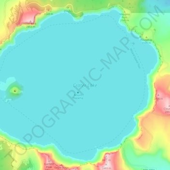
Nom : Carte topographique Crater Lake, altitude, relief.
Lieu : Crater Lake, Klamath County, Oregon, United States (42.90431 -122.16453 42.97874 -122.04998)
Altitude moyenne : 1’971 m
Altitude minimum : 1’853 m
Altitude maximum : 2’483 m
The lake is 5 by 6 miles (8.0 by 9.7 km) across, with a caldera rim ranging in elevation from 7,000 to 8,000 feet (2,100 to 2,400 m) and an average lake depth of 1,148 feet (350 m). The lake's maximum depth has been measured at 1,949 feet (594 m), which fluctuates slightly as the weather changes. On the basis of maximum depth, Crater Lake is the deepest lake in the United States, the second-deepest in North America (after Great Slave Lake in Canada), and the ninth-deepest lake in the world. Crater Lake is often cited as the seventh-deepest lake in the world, but this ranking excludes Lake Vostok in Antarctica, which is beneath about 13,000 feet (4,000 m) of ice, and the recent depth soundings of O'Higgins/San Martín Lake, which is along the border of Chile and Argentina.
Autres cartes topographiques
Cliquez sur une carte pour visualiser sa topographie, son altitude et son relief.
Deepest point -592m
United States > Oregon > Klamath County
Deepest point -592m, Klamath County, Oregon, United States
Altitude moyenne : 1’880 m
Link River
United States > Oregon > Klamath County > Klamath Falls
Link River, Klamath Falls, Klamath County, Oregon, United States
Altitude moyenne : 1’304 m
Chiloquin
United States > Oregon > Klamath County
Chiloquin, Klamath County, Oregon, United States
Altitude moyenne : 1’302 m
Willamette Pass
United States > Oregon > Klamath County
Willamette Pass, Klamath County, Oregon, United States
Altitude moyenne : 1’605 m
Crater Lake National Park
United States > Oregon > Klamath County
Crater Lake National Park, Klamath County, Oregon, 97604, United States
Altitude moyenne : 1’726 m
Klamath Falls
United States > Oregon > Klamath County
Klamath Falls, Klamath County, Oregon, 97601, United States
Altitude moyenne : 1’312 m