Géolocaliser

Carte topographique Waverley

Cliquez sur la carte pour afficher l’altitude.

À propos de cette carte

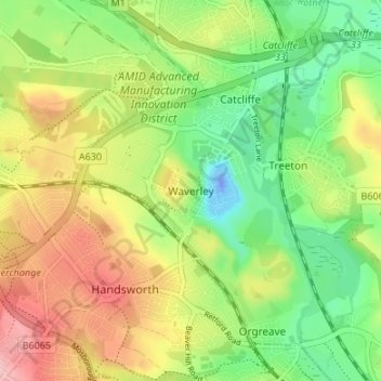
Nom : Carte topographique Waverley, altitude, relief.

Lieu : Waverley, Rotherham, South Yorkshire, England, S60 8AH, United Kingdom (53.36262 -1.39140 53.40262 -1.35140)

Altitude moyenne : 65 m

Altitude minimum : -38 m

Altitude maximum : 148 m

Autres cartes topographiques

Cliquez sur une carte pour visualiser sa topographie, son altitude et son relief.

Orgreave

United Kingdom > England > Rotherham

Altitude moyenne : 57 m

Bramley

United Kingdom > England > Rotherham

Altitude moyenne : 122 m

Brampton Bierlow

United Kingdom > England > Rotherham > Brampton

Altitude moyenne : 55 m

Waverley

United Kingdom > England > Rotherham

Altitude moyenne : 58 m

Wentworth

United Kingdom > England > Rotherham

Altitude moyenne : 96 m

Woodsetts

United Kingdom > England > Rotherham

Woodsetts is a village and civil parish in the Metropolitan Borough of Rotherham in South Yorkshire, England, on the border with Nottinghamshire. It lies between the towns of Dinnington and Worksop at an elevation of around 60 metres above sea level, and has a population of 1,746 at the 2011 Census. The…

Altitude moyenne : 70 m

Firbeck

United Kingdom > England > Rotherham

Altitude moyenne : 62 m

Walkworth Wood

United Kingdom > England > Rotherham

Altitude moyenne : 99 m

Thorpe Salvin

United Kingdom > England > Rotherham

Thorpe Salvin is a village and a civil parish in the Metropolitan Borough of Rotherham in South Yorkshire, England, on the border with Nottinghamshire. It lies between Worksop and Harthill, and is located at an elevation of around 110 metres above sea level. At the 2011 Census, it had a population of 476, down…

Altitude moyenne : 102 m

Wickersley

United Kingdom > England > Rotherham

Altitude moyenne : 116 m

Hellaby

United Kingdom > England > Rotherham

With a Dutch impression that was influenced by the style common in the colonies, the Hall was built on a hill and hence an extra storey was required to obtain the height at the front elevation.

Altitude moyenne : 113 m

Thrybergh

United Kingdom > England > Rotherham

Altitude moyenne : 48 m

Ulley

United Kingdom > England > Rotherham

Altitude moyenne : 92 m

Ravenfield

United Kingdom > England > Rotherham

Altitude moyenne : 86 m

Dalton

United Kingdom > England > Rotherham > Dalton Magna

Altitude moyenne : 100 m

Todwick

United Kingdom > England > Rotherham > Todwick

Altitude moyenne : 105 m

Thurcroft

United Kingdom > England > Rotherham

Altitude moyenne : 111 m

Équipez-vous pour votre prochaine aventure :

🧊Gourdes isothermes - Hydratation chaude ou froide en randonnée
Tente de bivouac légère - Idéale pour les nuits en pleine nature avec un encombrement minimal
🪖Casques d’escalade - Protection contre chutes de pierres
🧤Sous-vêtements techniques - Gestion thermique en effort
🌧️Poncho imperméable - Protection rapide et efficace contre les averses soudaines en montagne

En tant que Partenaire Amazon, ce site perçoit une commission sur les achats éligibles sans surcoût pour vous.