
Carte topographique Snelling
Carte interactive
Cliquez sur la carte pour afficher l’altitude.
À propos de cette carte
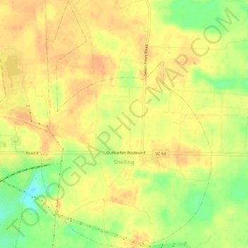
Nom : Carte topographique Snelling, altitude, relief.
Lieu : Snelling, Barnwell County, South Carolina, United States (33.22528 -81.47801 33.26721 -81.43815)
Altitude moyenne : 73 m
Altitude minimum : 48 m
Altitude maximum : 84 m
Autres cartes topographiques
Cliquez sur une carte pour visualiser sa topographie, son altitude et son relief.
Barnwell
United States > South Carolina > Barnwell County
Barnwell, Barnwell County, South Carolina, 29812, United States
Altitude moyenne : 64 m
Elko
United States > South Carolina > Barnwell County
Elko, Barnwell County, South Carolina, United States
Altitude moyenne : 99 m
Barnwell State Park
United States > South Carolina > Barnwell County > Blackville
Barnwell State Park, Blackville, Barnwell County, South Carolina, United States
Altitude moyenne : 84 m
Williston
United States > South Carolina > Barnwell County
Williston, Barnwell County, South Carolina, 29853, United States
Altitude moyenne : 102 m
Hilda
United States > South Carolina > Barnwell County
Hilda, Barnwell County, South Carolina, 29813, United States
Altitude moyenne : 78 m
Blackville
United States > South Carolina > Barnwell County
Blackville, Barnwell County, South Carolina, 29817, United States
Altitude moyenne : 85 m
Barnwell State Park
United States > South Carolina > Barnwell County
Barnwell State Park, Barnwell County, South Carolina, 29817, United States
Altitude moyenne : 83 m
Barnwell
United States > South Carolina > Barnwell County > Barnwell
Barnwell, Barnwell County, South Carolina, 29812, United States
Altitude moyenne : 65 m