
Carte topographique Braunlage
Carte interactive
Cliquez sur la carte pour afficher l’altitude.
Braunlage
Braunlage is located on the Warme Bode, a headstream of the river Bode, close to the border with Elend in the state of Saxony-Anhalt. The municipal area stretches along the south-eastern rim of the Harz National Park from an elevation of 550 m (1,800 ft) up to 971 m (3,186 ft) at the summit of the Wurmberg. Other peaks in the vicinity include the Achtermannshöhe and the Hahnenklee Crags.
À propos de cette carte
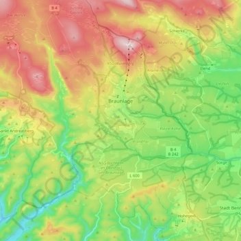
Nom : Carte topographique Braunlage, altitude, relief.
Lieu : Braunlage, Landkreis Goslar, Lower Saxony, Germany (51.65043 10.49042 51.78087 10.68399)
Altitude moyenne : 617 m
Altitude minimum : 365 m
Altitude maximum : 967 m