
Carte topographique Bayou Vista
Cliquez sur la carte pour afficher l’altitude.
À propos de cette carte
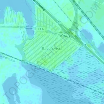
Nom : Carte topographique Bayou Vista, altitude, relief.
Lieu : Bayou Vista, Galveston County, Texas, United States (29.32028 -94.94719 29.33060 -94.92961)
Altitude moyenne : 2 m
Altitude minimum : -4 m
Altitude maximum : 6 m
Autres cartes topographiques
Cliquez sur une carte pour visualiser sa topographie, son altitude et son relief.
San Luis Pass
United States > Texas > Galveston County > Galveston
Tides cause daily variations in topography, and occasionally, storms more drastically change the topography of the pass.
Altitude moyenne : 0 m
San Luis Pass
United States > Texas > Galveston County > Galveston
Tides cause daily variations in topography, and occasionally, storms more drastically change the topography of the pass.
Altitude moyenne : 0 m
League City
United States > Texas > Galveston County > League City > League City
Altitude moyenne : 7 m
Bacliff
United States > Texas > Galveston County
After Hurricane Ike hit Texas in September 2008, Galveston County officials offered a debris removal program to residents in unincorporated areas, including Bacliff. Flooding from hurricane Ike was minimized due in part to Bacliff's relatively high elevation of 16 feet.
Altitude moyenne : 4 m