
Carte topographique Camberley
Cliquez sur la carte pour afficher l’altitude.
Camberley
The Staff College, to the north of Camberley town centre, is part of the Joint Services Command and Staff College, which provides training and education for established officers in the British Armed Forces and civil servants in the Ministry of Defence. The institution has its origins in the Royal Military College, High Wycombe, which was founded in 1799. It moved to Farnham in 1813, relocating seven years later to the Royal Military College at Sandhurst. The Staff College building was designed by James Pennethorne and constructed in 1862. It was primarily built using London stock bricks, although the front elevation is partially faced with stone. The uppermost storey was added in 1913.
À propos de cette carte
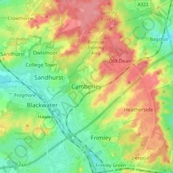
Nom : Carte topographique Camberley, altitude, relief.
Altitude moyenne : 88 m
Altitude minimum : 53 m
Altitude maximum : 137 m
Autres cartes topographiques
Cliquez sur une carte pour visualiser sa topographie, son altitude et son relief.
Chobham Common
United Kingdom > England > Surrey > Surrey Heath > Chobham > Brick Hill
Altitude moyenne : 49 m
Bagshot Park Mansion
United Kingdom > England > Surrey > Surrey Heath > Bagshot
Altitude moyenne : 76 m
Frimley Lodge Park
United Kingdom > England > Surrey > Surrey Heath > Frimley Green
Altitude moyenne : 80 m
Chobham
United Kingdom > England > Surrey > Surrey Heath
The rolling basin below reaches lowest elevations of between 30 metres (98 ft) in the centre of the west and 20 metres (66 ft) where the rivers join in the centre of the east. The rivers at the western point are less than 100 metres (330 ft) apart; to the east end of the parish where the parish adjoins the…
Altitude moyenne : 43 m