Carte topographique Calgary
Carte interactive
Cliquez sur la carte pour afficher l’altitude.
À propos de cette carte
![Carte topographique Calgary, altitude, relief](/pub/maps/relation/8d51/wnq557/thumbnail.jpg)
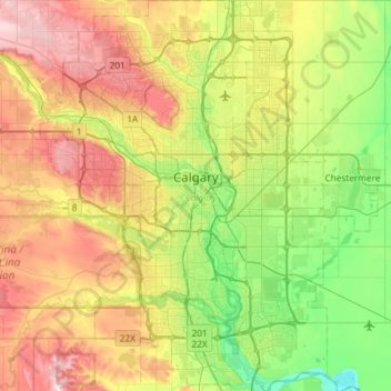
Nom : Carte topographique Calgary, altitude, relief.
Lieu : Calgary, Alberta, Canada (50.84253 -114.31576 51.21250 -113.86000)
Altitude moyenne : 1’106 m
Altitude minimum : 957 m
Altitude maximum : 1’349 m
Calgary est située dans les contreforts des montagnes Rocheuses, la région est donc plutôt montagneuse. La ville s'élève approximativement à 1 048 mètres d'altitude au centre-ville, et à 1 084 mètres à l'aéroport international de Calgary. Le territoire de la ville couvre une superficie de 721 km2 (en date de 2001) et dépasse donc les superficies de Toronto et de Montréal, les deux plus grandes villes du pays.
Autres cartes topographiques
Cliquez sur une carte pour visualiser sa topographie, son altitude et son relief.
![Carte topographique Mistaya Canyon, altitude, relief](/pub/maps/way/g53l/9d1jrw5k/icon.jpg)
Mistaya Canyon
Canada > Alberta > Division No. 15
Mistaya Canyon, Division No. 15, Alberta, Canada
Altitude moyenne : 1’547 m
![Carte topographique Canmore, altitude, relief](/pub/maps/node/9st6/82lfkf14/icon.jpg)
Canmore
Canada > Alberta > Division No. 15
Canmore, Division No. 15, Alberta, T1W 2H4, Canada
Altitude moyenne : 1’565 m
![Carte topographique High River, altitude, relief](/pub/maps/node/qp57/sbtndb3/icon.jpg)
High River
Canada > Alberta > Town of High River
High River, Town of High River, Alberta, T1V 1R6, Canada
Altitude moyenne : 1’042 m
![Carte topographique Pyramid Mountain, altitude, relief](/pub/maps/node/88dn/49w7vddn/icon.jpg)
Pyramid Mountain
Canada > Alberta > Division No. 15 > Municipality of Jasper
Pyramid Mountain, Municipality of Jasper, Division No. 15, Alberta, Canada
Altitude moyenne : 2’152 m
![Carte topographique Parc national de Banff, altitude, relief](/pub/maps/relation/7l18/988qs8/icon.jpg)
Parc national de Banff
Parc national de Banff, Alberta, Canada
Altitude moyenne : 1’848 m
![Carte topographique Saskatchewan River Crossing, altitude, relief](/pub/maps/node/rj5k/9sfjrl57/icon.jpg)
Saskatchewan River Crossing
Canada > Alberta > Improvement District No. 9
Saskatchewan River Crossing, Improvement District No. 9, Alberta, Canada
Altitude moyenne : 1’443 m
![Carte topographique Improvement District No. 9, altitude, relief](/pub/maps/relation/lk18/dw29rr/icon.jpg)
Improvement District No. 9
Improvement District No. 9, Alberta, Canada
Altitude moyenne : 1’848 m
![Carte topographique Hamlet of Monarch, altitude, relief](/pub/maps/relation/3fmt/nlkd5k/icon.jpg)
Hamlet of Monarch
Canada > Alberta > Lethbridge County
Hamlet of Monarch, Lethbridge County, Alberta, Canada
Altitude moyenne : 933 m
![Carte topographique Brule Lake, altitude, relief](/pub/maps/relation/4drr/dm6htp/icon.jpg)
Brule Lake
Canada > Alberta > Yellowhead County > Brûlé
Brule Lake, Brûlé, Yellowhead County, Alberta, Canada
Altitude moyenne : 1’250 m
![Carte topographique Vanrena, altitude, relief](/pub/maps/node/48gp/fzj82zs/icon.jpg)
Vanrena
Canada > Alberta > Municipal District of Fairview
Vanrena, Municipal District of Fairview, Alberta, Canada
Altitude moyenne : 601 m
![Carte topographique Mount Henday, altitude, relief](/pub/maps/node/gwt6/x1nrdqt6/icon.jpg)
Mount Henday
Canada > Alberta > Improvement District No. 12
Mount Henday, Improvement District No. 12, Alberta, Canada
Altitude moyenne : 2’334 m
![Carte topographique La Crete, altitude, relief](/pub/maps/node/b4tf/dfhvcszs/icon.jpg)
La Crete
Canada > Alberta > Mackenzie County
La Crete, Mackenzie County, Alberta, T0H 2H0, Canada
Altitude moyenne : 323 m
![Carte topographique Cairngorm, altitude, relief](/pub/maps/node/3mgt/mxgknfgt/icon.jpg)
Cairngorm
Canada > Alberta > Municipality of Jasper
Cairngorm, Municipality of Jasper, Alberta, Canada
Altitude moyenne : 2’240 m
![Carte topographique Cochrane, altitude, relief](/pub/maps/node/gs57/t6pltdn/icon.jpg)
Cochrane
Canada > Alberta > Town of Cochrane > Cochrane
Cochrane, Town of Cochrane, Alberta, T4V 2A7, Canada
Altitude moyenne : 1’205 m
![Carte topographique Prince's Island Park, altitude, relief](/pub/maps/way/khz4/9ks61kl/icon.jpg)
Prince's Island Park
Prince's Island Park, Eau Claire, Calgary, Alberta, T2P 0R1, Canada
Altitude moyenne : 1’065 m
![Carte topographique City of Red Deer, altitude, relief](/pub/maps/relation/9df3/mrcgdn/icon.jpg)
City of Red Deer
Canada > Alberta > Division No. 8
City of Red Deer, Division No. 8, Alberta, Canada
Altitude moyenne : 890 m
![Carte topographique Summer Village of Yellowstone, altitude, relief](/pub/maps/way/btp/ssrqncz/icon.jpg)
Summer Village of Yellowstone
Canada > Alberta > Yellowstone (summer village) > Summer Village of Yellowstone
Summer Village of Yellowstone, Yellowstone (summer village), Alberta, Canada
Altitude moyenne : 733 m
![Carte topographique Millet, altitude, relief](/pub/maps/node/glf3/gn2l673l/icon.jpg)
Millet
Canada > Alberta > Town of Millet > Millet
Millet, Town of Millet, Alberta, T0C 1Z0, Canada
Altitude moyenne : 765 m
![Carte topographique Crowsnest Pass (municipality), altitude, relief](/pub/maps/node/d818/6mnmk2gt/icon.jpg)
Crowsnest Pass (municipality)
Crowsnest Pass (municipality), Alberta, T0K 0M0, Canada
Altitude moyenne : 1’537 m
![Carte topographique Grande Prairie, altitude, relief](/pub/maps/relation/g8zs/lnpx14/icon.jpg)
Grande Prairie
Canada > Alberta > Division No. 19
Grande Prairie, Division No. 19, Alberta, Canada
Altitude moyenne : 665 m
![Carte topographique Comté de Strathcona, altitude, relief](/pub/maps/relation/qkl/zqgtj/icon.jpg)
Comté de Strathcona
Canada > Alberta > Comté de Strathcona
Comté de Strathcona, Alberta, Canada
Altitude moyenne : 691 m
![Carte topographique Edmonton, altitude, relief](/pub/maps/relation/kbkl/2614cz/icon.jpg)
Edmonton
Canada > Alberta > Division No. 11
Edmonton, Division No. 11, Alberta, Canada
Altitude moyenne : 690 m
![Carte topographique Town of Picture Butte, altitude, relief](/pub/maps/relation/46gt/w4mt18/icon.jpg)
Town of Picture Butte
Town of Picture Butte, Alberta, T0K 1V0, Canada
Altitude moyenne : 905 m
![Carte topographique Lake Louise, altitude, relief](/pub/maps/node/ntj/mkv9nxmt/icon.jpg)
Lake Louise
Canada > Alberta > Division No. 15
Lake Louise, Division No. 15, Alberta, Canada
Altitude moyenne : 1’617 m
![Carte topographique Town of Pincher Creek, altitude, relief](/pub/maps/relation/dmb3/r2jmnx/icon.jpg)
Town of Pincher Creek
Town of Pincher Creek, Alberta, T0K 1W0, Canada
Altitude moyenne : 1’149 m
![Carte topographique Avonmore, altitude, relief](/pub/maps/relation/k6s8/ckfh57/icon.jpg)
Avonmore
Canada > Alberta > Division No. 11
Avonmore, Mill Creek South, Division No. 11, Alberta, T6C 2N1, Canada
Altitude moyenne : 673 m
![Carte topographique Medicine Hat, altitude, relief](/pub/maps/relation/sxdn/lnnmz4/icon.jpg)
Medicine Hat
Canada > Alberta > Medicine Hat
Medicine Hat, Medicine Hat (city), Alberta, Canada
Altitude moyenne : 708 m
![Carte topographique Drumheller (town), altitude, relief](/pub/maps/node/s7gt/b7lhlr4s/icon.jpg)
Drumheller (town)
Drumheller (town), Alberta, T0J 2V0, Canada
Altitude moyenne : 855 m
![Carte topographique South Kootenay Pass, altitude, relief](/pub/maps/node/d99m/p82xqs3q/icon.jpg)
South Kootenay Pass
South Kootenay Pass, Mount Rowe to Sage Pass Route, Regional District of East Kootenay, Alberta, Canada
Altitude moyenne : 2’007 m
![Carte topographique Kananaskis Improvement District, altitude, relief](/pub/maps/relation/pvrr/7956gt/icon.jpg)
Kananaskis Improvement District
Kananaskis Improvement District, Alberta, Canada
Altitude moyenne : 1’740 m