
Carte topographique Mountain River
Carte interactive
Cliquez sur la carte pour afficher l’altitude.
À propos de cette carte
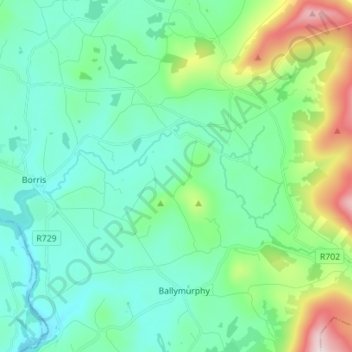
Nom : Carte topographique Mountain River, altitude, relief.
Altitude moyenne : 136 m
Altitude minimum : 11 m
Altitude maximum : 576 m
Autres cartes topographiques
Cliquez sur une carte pour visualiser sa topographie, son altitude et son relief.
Fennagh
Fennagh, Ballyknockan, Fennagh ED, The Municipal District of Muinebeag, County Carlow, Leinster, Ireland
Altitude moyenne : 96 m
Castlemore
Castlemore, Tullowbeg ED, The Municipal District of Tullow, County Carlow, Leinster, Ireland
Altitude moyenne : 78 m
Derreen
Derreen, Butlersgrange, Tullow Rural ED, The Municipal District of Tullow, County Carlow, Leinster, Ireland
Altitude moyenne : 95 m
Bagenalstown
Ireland > County Carlow > Bagenalstown
Bagenalstown, The Municipal District of Muinebeag, County Carlow, Leinster, R21 DR77, Ireland
Altitude moyenne : 75 m
Palatine
Palatine, Killyshane, Burtonhall ED, The Municipal District of Carlow, County Carlow, Leinster, R93 Y381, Ireland
Altitude moyenne : 76 m
Borris
Borris, The Municipal District of Muinebeag, County Carlow, Leinster, R95 C92R, Ireland
Altitude moyenne : 60 m
Vermount
Vermount, Clonmore ED, The Municipal District of Tullow, County Carlow, Leinster, Ireland
Altitude moyenne : 153 m