
Carte topographique Dhulikhel
Carte interactive
Cliquez sur la carte pour afficher l’altitude.
À propos de cette carte
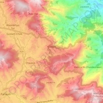
Nom : Carte topographique Dhulikhel, altitude, relief.
Lieu : Dhulikhel, Kavrepalanchok, Bagmati Pradesh, Nepal (27.59224 85.53050 27.63848 85.61317)
Altitude moyenne : 1’436 m
Altitude minimum : 903 m
Altitude maximum : 1’816 m
Autres cartes topographiques
Cliquez sur une carte pour visualiser sa topographie, son altitude et son relief.
Banepa
Banepa, Kavrepalanchok, Bagmati Pradesh, Nepal
Altitude moyenne : 1’559 m
Nagarkot
Nepal > Kavrepalanchok > Tukucha Nala
Nagarkot, Tukucha Nala, Banepa, Kavrepalanchok, Bagmati Pradesh, 44812, Nepal
Altitude moyenne : 1’886 m