Carte topographique Elgin
Cliquez sur la carte pour afficher l’altitude.
Elgin
Elgin is first documented in the Cartulary of Moray in 1190 AD. It was created a royal burgh in the 12th century by King David I of Scotland, and by that time had a castle on top of the present-day Lady Hill to the west of the town. The origin of the name Elgin is likely to be Celtic. It may derive from 'Aille' literally signifying beauty, but in topography a beautiful place or valley. Another possibility is 'ealg', meaning both 'Ireland' and 'worthy'. The termination 'gin' or 'in' are Celtic endings signifying little or diminutive forms, hence Elgin could mean beautiful place, worthy place or little Ireland.
À propos de cette carte
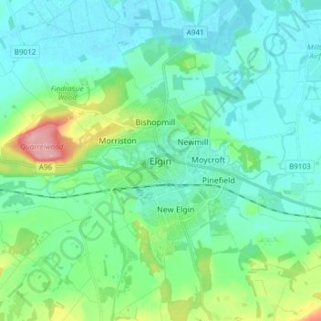
Nom : Carte topographique Elgin, altitude, relief.
Lieu : Elgin, Moray, Scotland, IV30 1EA, United Kingdom (57.60879 -3.35485 57.68879 -3.27485)
Altitude moyenne : 26 m
Altitude minimum : -1 m
Altitude maximum : 125 m
Autres cartes topographiques
Cliquez sur une carte pour visualiser sa topographie, son altitude et son relief.
Fochabers
United Kingdom > Scotland > Moray
The present village owes its existence to Alexander Gordon, 4th Duke of Gordon (1743–1827). During the late eighteenth century, during the Scottish Enlightenment, it was fashionable for landowners to found new towns and villages; these can be recognised all over Scotland, because unlike their predecessors…
Altitude moyenne : 59 m