
Carte topographique Bellingham
Carte interactive
Cliquez sur la carte pour afficher l’altitude.
À propos de cette carte
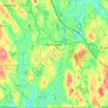
Nom : Carte topographique Bellingham, altitude, relief.
Altitude moyenne : 84 m
Altitude minimum : 45 m
Altitude maximum : 153 m
According to the United States Census Bureau, the town has a total area of 19.0 square miles (49.2 km2), of which 18.5 square miles (47.9 km2) is land and 0.5 square mile (1.3 km2) (2.58%) is water. The town's mean elevation is 293 feet (89 m) above sea level.
Autres cartes topographiques
Cliquez sur une carte pour visualiser sa topographie, son altitude et son relief.
Wethersfield
United States > Massachusetts > Norfolk County > Bellingham
Wethersfield, Bellingham, Norfolk County, Massachusetts, 02019, United States
Altitude moyenne : 76 m