
Carte topographique Curepipe
Carte interactive
Cliquez sur la carte pour afficher l’altitude.
À propos de cette carte
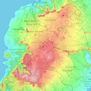
Nom : Carte topographique Curepipe, altitude, relief.
Altitude moyenne : 278 m
Altitude minimum : 0 m
Altitude maximum : 806 m
Curepipe (Mauritian Creole pronunciation: [kiːəpip]) also known as La Ville-Lumière (The City of Light), is a town in Mauritius, located in the Plaines Wilhems District, the eastern part also lies in the Moka District. The town is administered by the Municipal Council of Curepipe. Curepipe lies at a higher elevation, often referred to as the "Central Plateau". According to the census made by Statistics Mauritius in 2018, the population of the town was at 78,618.