
Carte topographique Peachtree City
Carte interactive
Cliquez sur la carte pour afficher l’altitude.
À propos de cette carte
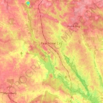
Nom : Carte topographique Peachtree City, altitude, relief.
Altitude moyenne : 262 m
Altitude minimum : 180 m
Altitude maximum : 309 m
Shakerag Hill, with an elevation of 980 feet (300 m), is the highest point in the city and sits on the eastern border at the intersection of GA Hwy 54 and Robinson Road.
Autres cartes topographiques
Cliquez sur une carte pour visualiser sa topographie, son altitude et son relief.
Huntington Place
United States > Georgia > Fayette County > Peachtree City
Huntington Place, Peachtree City, Fayette County, Georgia, 30269, United States
Altitude moyenne : 249 m
Fayetteville
United States > Georgia > Fayette County
Fayetteville, Fayette County, Georgia, United States
Altitude moyenne : 265 m
Tamerlane
United States > Georgia > Fayette County > Peachtree City > Tamerlane
Tamerlane, Peachtree City, Fayette County, Georgia, 30269, United States
Altitude moyenne : 247 m