
Carte topographique Mitchell
Carte interactive
Cliquez sur la carte pour afficher l’altitude.
À propos de cette carte
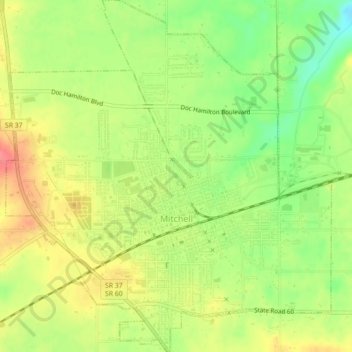
Nom : Carte topographique Mitchell, altitude, relief.
Lieu : Mitchell, Lawrence County, Indiana, 47446, United States (38.71975 -86.49511 38.75428 -86.45410)
Altitude moyenne : 209 m
Altitude minimum : 174 m
Altitude maximum : 242 m
Autres cartes topographiques
Cliquez sur une carte pour visualiser sa topographie, son altitude et son relief.
Otis Park
United States > Indiana > Lawrence County > Bedford
Otis Park, Bedford, Lawrence County, Indiana, United States
Altitude moyenne : 186 m
Bedford
United States > Indiana > Lawrence County
Bedford, Lawrence County, Indiana, 47421, United States
Altitude moyenne : 191 m
Rabbitville
United States > Indiana > Lawrence County
Rabbitville, Lawrence County, Indiana, 47446, United States
Altitude moyenne : 196 m
Crawford
United States > Indiana > Lawrence County > Crawford
Crawford, Lawrence County, Indiana, United States
Altitude moyenne : 198 m
Springville
United States > Indiana > Lawrence County > Springville
Springville, Lawrence County, Indiana, United States
Altitude moyenne : 219 m