
Carte topographique Bossier City
Carte interactive
Cliquez sur la carte pour afficher l’altitude.
À propos de cette carte
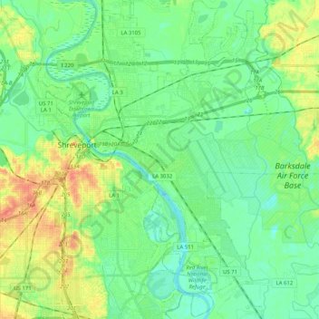
Nom : Carte topographique Bossier City, altitude, relief.
Lieu : Bossier City, Bossier Parish, Louisiana, United States (32.41979 -93.74928 32.59081 -93.58433)
Altitude moyenne : 55 m
Altitude minimum : 40 m
Altitude maximum : 85 m
Bossier City is located at 32°31′4″N 93°41′29″W / 32.51778°N 93.69139°W / 32.51778; -93.69139 (32.517651, −93.691397) within the Ark-La-Tex and has an elevation of 174 feet (53.0 m) above sea level. The city lies primarily on the banks of the Red River, and has a largely flat topography in contrast with Shreveport's terrain. The northern city limits are noticeably more hilly than the rest of the city. Many small waterways flow through the city, such as Flat River and Red Chute Bayou, which provide drainage for many areas of the city.
Autres cartes topographiques
Cliquez sur une carte pour visualiser sa topographie, son altitude et son relief.
Waller
United States > Louisiana > Bossier Parish > Bossier City
Waller, Bossier City, Bossier Parish, Louisiana, 71171, United States
Altitude moyenne : 53 m
Fillmore
United States > Louisiana > Bossier Parish
Fillmore, Bossier Parish, Louisiana, 71067, United States
Altitude moyenne : 81 m
Bossier City
United States > Louisiana > Bossier Parish
Bossier City, Bossier Parish, Louisiana, United States
Altitude moyenne : 55 m
Benton
United States > Louisiana > Bossier Parish
Benton, Bossier Parish, Louisiana, United States
Altitude moyenne : 62 m
Plain Dealing
United States > Louisiana > Bossier Parish
Plain Dealing, Bossier Parish, Louisiana, 71064, United States
Altitude moyenne : 93 m
Alden Bridge
United States > Louisiana > Bossier Parish
Alden Bridge, Bossier Parish, Louisiana, United States
Altitude moyenne : 69 m