
Carte topographique Hawleyville
Carte interactive
Cliquez sur la carte pour afficher l’altitude.
À propos de cette carte
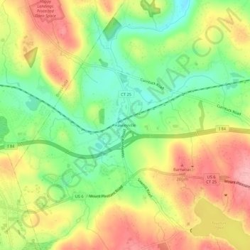
Nom : Carte topographique Hawleyville, altitude, relief.
Altitude moyenne : 145 m
Altitude minimum : 80 m
Altitude maximum : 213 m
Autres cartes topographiques
Cliquez sur une carte pour visualiser sa topographie, son altitude et son relief.
Dodgingtown
United States > Connecticut > Western Connecticut Planning Region > Newtown
Dodgingtown, Newtown, Western Connecticut Planning Region, Connecticut, 06470, United States
Altitude moyenne : 180 m
Hattertown
United States > Connecticut > Western Connecticut Planning Region > Newtown
Hattertown, Newtown, Western Connecticut Planning Region, Connecticut, United States
Altitude moyenne : 182 m
Cedarhurst
United States > Connecticut > Western Connecticut Planning Region > Newtown
Cedarhurst, Newtown, Western Connecticut Planning Region, Connecticut, 06482, United States
Altitude moyenne : 111 m
Sandy Hook
United States > Connecticut > Western Connecticut Planning Region > Newtown
Sandy Hook, Newtown, Western Connecticut Planning Region, Connecticut, 01103, United States
Altitude moyenne : 113 m
Botsford
United States > Connecticut > Western Connecticut Planning Region > Newtown
Botsford, Newtown, Western Connecticut Planning Region, Connecticut, 06482, United States
Altitude moyenne : 140 m