
Carte topographique Rosses Point
Cliquez sur la carte pour afficher l’altitude.
À propos de cette carte
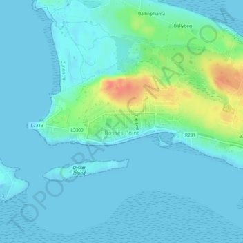
Nom : Carte topographique Rosses Point, altitude, relief.
Lieu : Rosses Point, County Sligo, Connacht, Ireland (54.30197 -8.56761 54.31236 -8.52688)
Altitude moyenne : 8 m
Altitude minimum : -1 m
Altitude maximum : 46 m
Autres cartes topographiques
Cliquez sur une carte pour visualiser sa topographie, son altitude et son relief.
Easky
In Samuel Lewis's 1837 publication of A Topographical Dictionary of Ireland, Easky was described as having 6,124 inhabitants, of which 289 were in the village. Lewis noted that the village (made up of one long street) had petty sessions every fortnight and that Wednesday was market day. As well as other more…
Altitude moyenne : 17 m