
Carte topographique Findhorn
Carte interactive
Cliquez sur la carte pour afficher l’altitude.
À propos de cette carte
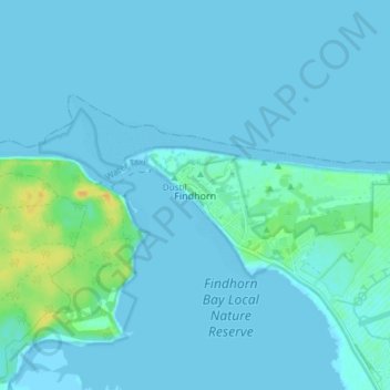
Nom : Carte topographique Findhorn, altitude, relief.
Lieu : Findhorn, Moray, Scotland, IV36 3YG, United Kingdom (57.63911 -3.63070 57.67911 -3.59070)
Altitude moyenne : 3 m
Altitude minimum : -1 m
Altitude maximum : 24 m
Autres cartes topographiques
Cliquez sur une carte pour visualiser sa topographie, son altitude et son relief.
Dyke
United Kingdom > Scotland > Moray
Dyke, Moray, Scotland, IV36 2TJ, United Kingdom
Altitude moyenne : 24 m
Forres
United Kingdom > Scotland > Moray
Forres, Moray, Scotland, IV36 1NX, United Kingdom
Altitude moyenne : 31 m
Dunphail
United Kingdom > Scotland > Moray
Dunphail, Moray, Scotland, IV36 2QQ, United Kingdom
Altitude moyenne : 192 m
Portgordon
United Kingdom > Scotland > Moray
Portgordon, Moray, Scotland, AB56 5TL, United Kingdom
Altitude moyenne : 22 m
Glenlivet
United Kingdom > Scotland > Moray > Glenlivet
Glenlivet, Moray, Scotland, AB37 9BT, United Kingdom
Altitude moyenne : 280 m