
Carte topographique Mannarkkad
Carte interactive
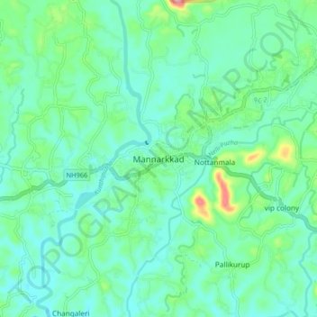
Cliquez sur la carte pour afficher l’altitude.
À propos de cette carte
Nom : Carte topographique Mannarkkad, altitude, relief.
Altitude moyenne : 80 m
Altitude minimum : 47 m
Altitude maximum : 201 m
Mannarkkad is located at 10°59′N 76°28′E / 10.98°N 76.47°E / 10.98; 76.47. It has an average elevation of 76 m (249 ft). Mannarkkad is located 36 km north-west of district headquarters Palakkad, along National Highway 966 and 100 km north west of Kozhikode. Mannarkkad is located in the foothills of the Western Ghats.
Autres cartes topographiques
Cliquez sur une carte pour visualiser sa topographie, son altitude et son relief.