
Carte topographique Leipzig
Carte interactive
Cliquez sur la carte pour afficher l’altitude.
À propos de cette carte
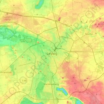
Nom : Carte topographique Leipzig, altitude, relief.
Lieu : Leipzig, Saxony, Germany (51.23817 12.23665 51.44811 12.54244)
Altitude moyenne : 126 m
Altitude minimum : 82 m
Altitude maximum : 177 m
Autres cartes topographiques
Cliquez sur une carte pour visualiser sa topographie, son altitude et son relief.
Mandau/Mandava
Germany > Saxony > Görlitz - Zhorjelc
Mandau/Mandava, Görlitz - Zhorjelc, Saxony, Germany
Altitude moyenne : 415 m
Bonbon
Germany > Saxony > Sächsische Schweiz-Osterzgebirge > Bad Schandau
Bonbon, Bad Schandau, Sächsische Schweiz-Osterzgebirge, Saxony, Germany
Altitude moyenne : 340 m
Bischofswerda
Germany > Saxony > Bischofswerda
Bischofswerda, Bautzen, Saxony, 01877, Germany
Altitude moyenne : 314 m
Muldenhammer
Germany > Saxony > Muldenhammer
Muldenhammer, Vogtlandkreis, Saxony, Germany
Altitude moyenne : 746 m
Fichtelberg
Germany > Saxony > Oberwiesenthal
Fichtelberg, Oberwiesenthal, Erzgebirgskreis, Saxony, 09484, Germany
Altitude moyenne : 1’038 m