
Faire un don
Équipez-vous pour votre prochaine aventure :
En tant que Partenaire Amazon, ce site perçoit une commission sur les achats éligibles sans surcoût pour vous.
Carte topographique Great Dun Fell
Cliquez sur la carte pour afficher l’altitude.
Faire un don
Équipez-vous pour votre prochaine aventure :
En tant que Partenaire Amazon, ce site perçoit une commission sur les achats éligibles sans surcoût pour vous.
Great Dun Fell
Under the Köppen climate classification, Great Dun Fell has a subpolar oceanic climate (Cfc), closely bordering both a subarctic climate (Dfc) under the 0 °C (32 °F) isotherm and an alpine tundra climate (ET) due to a July mean of exactly 10 °C (50 °F). The Met Office station publishes only temperature, wind and frost averages. The summers are cool due to elevation. Considering its elevation and a latitude of over 54 degrees, winters are relatively mild due to oceanic influences.
Faire un don
Équipez-vous pour votre prochaine aventure :
En tant que Partenaire Amazon, ce site perçoit une commission sur les achats éligibles sans surcoût pour vous.
À propos de cette carte
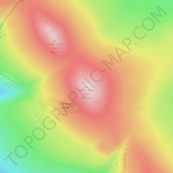
Nom : Carte topographique Great Dun Fell, altitude, relief.
Altitude moyenne : 713 m
Altitude minimum : 526 m
Altitude maximum : 851 m
Faire un don
Équipez-vous pour votre prochaine aventure :
En tant que Partenaire Amazon, ce site perçoit une commission sur les achats éligibles sans surcoût pour vous.