Géolocaliser

Carte topographique Upper Harbledown

Cliquez sur la carte pour afficher l’altitude.

À propos de cette carte

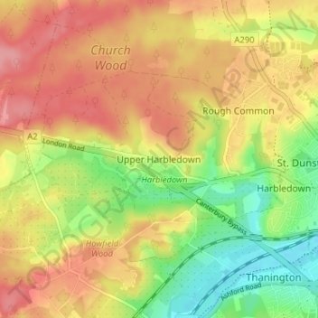
Nom : Carte topographique Upper Harbledown, altitude, relief.

Lieu : Upper Harbledown, Canterbury, Kent, England, CT2 9AN, United Kingdom (51.26546 1.01140 51.30546 1.05140)

Altitude moyenne : 60 m

Altitude minimum : 8 m

Altitude maximum : 102 m

Autres cartes topographiques

Cliquez sur une carte pour visualiser sa topographie, son altitude et son relief.

Wickhambreaux

United Kingdom > England > Kent > Canterbury

Altitude moyenne : 13 m

Bishopsbourne

United Kingdom > England > Kent > Canterbury > Bishopsbourne

Altitude moyenne : 79 m

Kingston

United Kingdom > England > Kent > Canterbury

Altitude moyenne : 84 m

Littlebourne

United Kingdom > England > Kent > Canterbury

Altitude moyenne : 21 m

Hoath

United Kingdom > England > Kent > Canterbury

Altitude moyenne : 24 m

Sturry

United Kingdom > England > Kent > Canterbury

Altitude moyenne : 32 m

Kingston

United Kingdom > England > Kent > Canterbury

Altitude moyenne : 84 m

Chestfield

United Kingdom > England > Kent > Canterbury

Altitude moyenne : 34 m

Petham

United Kingdom > England > Kent > Canterbury > Petham

Altitude moyenne : 96 m

Upper Hardres

United Kingdom > England > Kent > Canterbury

Altitude moyenne : 120 m

Hersden

United Kingdom > England > Kent > Canterbury

Altitude moyenne : 19 m

Barham

United Kingdom > England > Kent > Canterbury

Altitude moyenne : 99 m

Chartham

United Kingdom > England > Kent > Canterbury

Altitude moyenne : 60 m

Westbere

United Kingdom > England > Kent > Canterbury

Altitude moyenne : 21 m

Waltham

United Kingdom > England > Kent > Canterbury

Altitude moyenne : 127 m

Thanington

United Kingdom > England > Kent > Canterbury

Altitude moyenne : 49 m

Adisham

United Kingdom > England > Kent > Canterbury

Altitude moyenne : 63 m

Fordwich

United Kingdom > England > Kent > Canterbury

Altitude moyenne : 25 m

Équipez-vous pour votre prochaine aventure :

🗺️Cartes de randonnée - Le support papier indispensable en complément du numérique
🗺️Cartes topographiques papier - Cartes détaillées pour randonnée, orientation et lecture du relief
🪓Piolets d’alpinisme - Équipement essentiel pour terrain glacé
📷Appareil photo de sport - Capturez vos exploits même sous la pluie ou dans la neige
🛏️Sacs de couchage - Sacs de couchage adaptés à toutes saisons

En tant que Partenaire Amazon, ce site perçoit une commission sur les achats éligibles sans surcoût pour vous.