
Carte topographique Moosburg
Carte interactive
Cliquez sur la carte pour afficher l’altitude.
À propos de cette carte
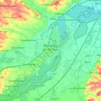
Nom : Carte topographique Moosburg, altitude, relief.
Lieu : Moosburg, Landkreis Freising, Bavaria, 85368, Germany (48.42698 11.86724 48.49993 12.01942)
Altitude moyenne : 428 m
Altitude minimum : 397 m
Altitude maximum : 513 m
The oldest town between Regensburg and Italy, it lies on the river Isar at an altitude of 421 m (1381 ft). It has 20,237 inhabitants (2022) and covers an area of 44 km2. It is easily reached by the A 92 autobahn and regional trains on the Munich–Regensburg line. Furthermore, it takes just 20 minutes to get to Munich Airport.
Autres cartes topographiques
Cliquez sur une carte pour visualiser sa topographie, son altitude et son relief.
Neufahrn bei Freising
Germany > Bavaria > Landkreis Freising
Neufahrn bei Freising, Landkreis Freising, Bavaria, Germany
Altitude moyenne : 464 m
85413
Germany > Bavaria > Landkreis Freising > Margarethenried > Sixt in der Point
85413, Sixt in der Point, Margarethenried, Hörgertshausen, Mauern (VGem), Landkreis Freising, Bavaria, Germany
Altitude moyenne : 484 m
Dietersheim
Germany > Bavaria > Landkreis Freising
Dietersheim, Eching, Landkreis Freising, Bavaria, 85386, Germany
Altitude moyenne : 471 m
Günzenhausen
Germany > Bavaria > Landkreis Freising
Günzenhausen, Eching, Landkreis Freising, Bavaria, 85376, Germany
Altitude moyenne : 477 m
Mariabrunn
Germany > Bavaria > Landkreis Freising > Birkeneck
Mariabrunn, Birkeneck, Hallbergmoos, Landkreis Freising, Bavaria, 85399, Germany
Altitude moyenne : 453 m
Spörerau
Germany > Bavaria > Landkreis Freising > Wang
Spörerau, Wang, Mauern (VGem), Landkreis Freising, Bavaria, 84079, Germany
Altitude moyenne : 410 m
Freising
Germany > Bavaria > Landkreis Freising
Freising, Landkreis Freising, Bavaria, Germany
Altitude moyenne : 457 m