
Carte topographique Paw Paw
Carte interactive
Cliquez sur la carte pour afficher l’altitude.
À propos de cette carte
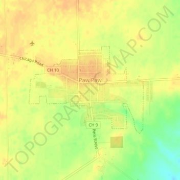
Nom : Carte topographique Paw Paw, altitude, relief.
Altitude moyenne : 283 m
Altitude minimum : 261 m
Altitude maximum : 293 m
Autres cartes topographiques
Cliquez sur une carte pour visualiser sa topographie, son altitude et son relief.
Dixon
United States > Illinois > Lee County
Dixon, Dixon Township, Lee County, Illinois, 61021, United States
Altitude moyenne : 228 m
Amboy
United States > Illinois > Lee County
Amboy, Amboy Township, Lee County, Illinois, 61310, United States
Altitude moyenne : 239 m
Sublette
United States > Illinois > Lee County
Sublette, Sublette Township, Lee County, Illinois, United States
Altitude moyenne : 277 m