
Carte topographique Yalaha
Cliquez sur la carte pour afficher l’altitude.
À propos de cette carte
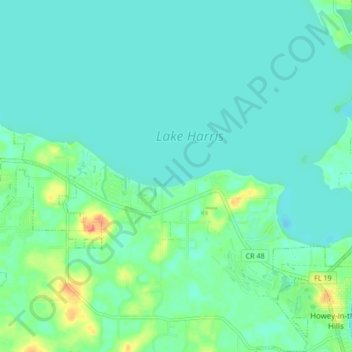
Nom : Carte topographique Yalaha, altitude, relief.
Lieu : Yalaha, Lake County, Florida, 34797, United States (28.71038 -81.86304 28.78446 -81.78033)
Altitude moyenne : 24 m
Altitude minimum : 14 m
Altitude maximum : 59 m
Autres cartes topographiques
Cliquez sur une carte pour visualiser sa topographie, son altitude et son relief.
Lake Harris
United States > Florida > Lake County > Yalaha
Lake Harris' primary inflow is at its southwestern shore from the Palatlakaha River, which originates from the Clermont chain of lakes to the south. Other inflowing rivers include Helena Run and discharge from many small springs in Yalaha. Lake Harris' depth is much greater than Lake Okeechobee to the south,…
Altitude moyenne : 25 m