
Carte topographique Days Bay
Carte interactive
Cliquez sur la carte pour afficher l’altitude.
À propos de cette carte
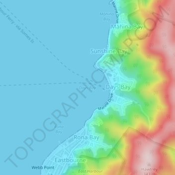
Nom : Carte topographique Days Bay, altitude, relief.
Lieu : Days Bay, Lower Hutt, Wellington, 5013, New Zealand (-41.28022 174.90189 -41.28012 174.90199)
Altitude moyenne : 74 m
Altitude minimum : 0 m
Altitude maximum : 331 m
Autres cartes topographiques
Cliquez sur une carte pour visualiser sa topographie, son altitude et son relief.
Somes Island
New Zealand > Wellington > Lower Hutt
Somes Island, Lower Hutt, Wellington, New Zealand
Altitude moyenne : 1 m
Hutt River
New Zealand > Wellington > Lower Hutt
Hutt River, Lower Hutt, Lower Hutt City, Wellington, 5019, New Zealand
Altitude moyenne : 97 m
Towai
New Zealand > Wellington > Lower Hutt
Towai, Lower Hutt, Lower Hutt City, Wellington, 5010, New Zealand
Altitude moyenne : 123 m
Lake Kohangapiripiri
New Zealand > Wellington > Lower Hutt
Lake Kohangapiripiri, Kohangapiripiri Track, Lower Hutt, Lower Hutt City, Wellington, New Zealand
Altitude moyenne : 32 m