
Carte topographique Den Ilp
Carte interactive
Cliquez sur la carte pour afficher l’altitude.
À propos de cette carte
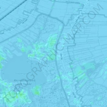
Nom : Carte topographique Den Ilp, altitude, relief.
Lieu : Den Ilp, Landsmeer, Nordholland, Niederlande (52.44424 4.89303 52.47195 4.91954)
Altitude moyenne : -1 m
Altitude minimum : -7 m
Altitude maximum : 7 m
Autres cartes topographiques
Cliquez sur une carte pour visualiser sa topographie, son altitude et son relief.
Landsmeer
Niederlande > Nordholland > Landsmeer
Landsmeer, Nordholland, Niederlande
Altitude moyenne : -1 m
Purmerland
Niederlande > Nordholland > Landsmeer
Purmerland, Landsmeer, Nordholland, Niederlande
Altitude moyenne : -2 m