
Carte topographique Dezful
Carte interactive
Cliquez sur la carte pour afficher l’altitude.
Dezful
Dezful is 650 kilometers away from the national capital of Tehran and 155 kilometres away from the provincial capital of Ahvaz. The city is located 300 kilometres from the Persian Gulf and is at an altitude of 143 meters.
À propos de cette carte
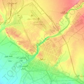
Nom : Carte topographique Dezful, altitude, relief.
Lieu : Dezful, بخش مرکزی, Dezful County, Khuzestan Province, Iran (32.34519 48.34017 32.45861 48.48374)
Altitude moyenne : 137 m
Altitude minimum : 105 m
Altitude maximum : 169 m
Autres cartes topographiques
Cliquez sur une carte pour visualiser sa topographie, son altitude et son relief.
دره ارواح
Iran > Khuzestan Province > Dezful County > دهستان شهی > Bisheh Bozān
Altitude moyenne : 593 m