
Carte topographique Grand Teton National Park
Carte interactive
Cliquez sur la carte pour afficher l’altitude.
À propos de cette carte
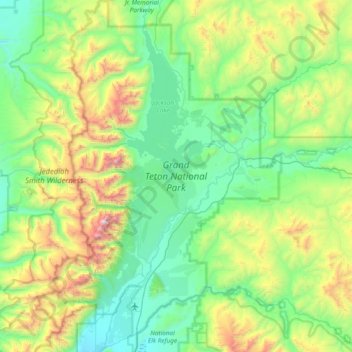
Nom : Carte topographique Grand Teton National Park, altitude, relief.
Altitude moyenne : 2’409 m
Altitude minimum : 1’893 m
Altitude maximum : 4’117 m
Grand Teton National Park is named for Grand Teton, the tallest mountain in the Teton Range. The naming of the mountains is attributed to early 19th-century French-speaking trappers—les trois tétons (the three teats) was later anglicized and shortened to Tetons. At 13,775 feet (4,199 m), Grand Teton abruptly rises more than 7,000 feet (2,100 m) above Jackson Hole, almost 850 feet (260 m) higher than Mount Owen, the second-highest summit in the range. The park has numerous lakes, including 15-mile-long (24 km) Jackson Lake as well as streams of varying length and the upper main stem of the Snake River. Though in a state of recession, a dozen small glaciers persist at the higher elevations near the highest peaks in the range. Some of the rocks in the park are the oldest found in any American national park and have been dated at nearly 2.7 billion years.
Autres cartes topographiques
Cliquez sur une carte pour visualiser sa topographie, son altitude et son relief.
Rocky Mountains
United States > Wyoming > Teton County
Rocky Mountains, Teton County, Wyoming, United States
Altitude moyenne : 2’292 m
Buck Mountain
United States > Wyoming > Teton County
Buck Mountain, Teton County, Wyoming, United States
Altitude moyenne : 3’128 m
Jenny Lake
United States > Wyoming > Teton County
Jenny Lake, Teton County, Wyoming, United States
Altitude moyenne : 2’109 m
Delusion Lake
United States > Wyoming > Teton County
Delusion Lake, Teton County, Wyoming, United States
Altitude moyenne : 2’398 m
South Park
United States > Wyoming > Teton County > Rafter J Ranch
South Park, Rafter J Ranch, Teton County, Wyoming, United States
Altitude moyenne : 1’928 m
Heart Lake
United States > Wyoming > Teton County
Heart Lake, Teton County, Wyoming, United States
Altitude moyenne : 2’301 m
Wilson
United States > Wyoming > Teton County > Wilson
Wilson, Teton County, Wyoming, United States
Altitude moyenne : 2’208 m
Rendezvous Mountain
United States > Wyoming > Teton County > Teton Village
Rendezvous Mountain, Teton Village, Teton County, Wyoming, 83025, United States
Altitude moyenne : 2’829 m
Jackson
United States > Wyoming > Teton County
Jackson, Teton County, Wyoming, 83002, United States
Altitude moyenne : 2’043 m
Grand Teton
United States > Wyoming > Teton County
Grand Teton, Teton County, Wyoming, United States
Altitude moyenne : 3’330 m
Teton Village
United States > Wyoming > Teton County
Teton Village, Teton County, Wyoming, 83025, United States
Altitude moyenne : 2’323 m
Bobcat Ridge
United States > Wyoming > Teton County
Bobcat Ridge, Teton County, Wyoming, United States
Altitude moyenne : 2’753 m
Moose
United States > Wyoming > Teton County
Moose, Teton County, Wyoming, United States
Altitude moyenne : 2’011 m
Upper Geyser Basin
United States > Wyoming > Teton County
Upper Geyser Basin, Teton County, Wyoming, United States
Altitude moyenne : 2’295 m
Mount Moran
United States > Wyoming > Teton County
Mount Moran, Teton County, Wyoming, United States
Altitude moyenne : 3’090 m
Yellowstone Caldera Supervolcano
United States > Wyoming > Teton County
Yellowstone Caldera Supervolcano, Teton County, Wyoming, United States
Altitude moyenne : 2’530 m
Beaver Creek
United States > Wyoming > Teton County
Beaver Creek, Teton County, Wyoming, 83012, United States
Altitude moyenne : 2’043 m
Yellowstone Lake
United States > Wyoming > Teton County
Yellowstone Lake, Teton County, Wyoming, United States
Altitude moyenne : 2’453 m
Jackson Lake
United States > Wyoming > Teton County
Jackson Lake, Teton County, Wyoming, United States
Altitude moyenne : 2’349 m
Grant Village
United States > Wyoming > Teton County
Grant Village, Teton County, Wyoming, United States
Altitude moyenne : 2’391 m