
Carte topographique Bull Lake Glacier
Carte interactive
Cliquez sur la carte pour afficher l’altitude.
À propos de cette carte
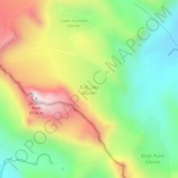
Nom : Carte topographique Bull Lake Glacier, altitude, relief.
Altitude moyenne : 3’643 m
Altitude minimum : 3’303 m
Altitude maximum : 4’117 m
Autres cartes topographiques
Cliquez sur une carte pour visualiser sa topographie, son altitude et son relief.
Wind River Range
Wind River Range, Fremont County, Wyoming, USA
Altitude moyenne : 3’706 m
Middle Teton Glacier
USA > Wyoming > Beaver Creek
Middle Teton Glacier, Garnet Canyon Trail, Beaver Creek, Teton County, Wyoming, USA
Altitude moyenne : 3’383 m
DuNoir Glacier
DuNoir Glacier, East Dunoir Trail, Fremont County, Wyoming, USA
Altitude moyenne : 3’236 m
Black Tooth Mountain
Black Tooth Mountain, Johnson County, Wyoming, USA
Altitude moyenne : 3’511 m
Heap Steep Glacier
Heap Steep Glacier, Glacier Trail, Fremont County, Wyoming, USA
Altitude moyenne : 3’698 m
Medicine Bow Peak
Medicine Bow Peak, Albany County, Wyoming, USA
Altitude moyenne : 3’396 m
Sourdough Glacier
Sourdough Glacier, Sublette County, Wyoming, USA
Altitude moyenne : 3’701 m
Petersen Glacier
Petersen Glacier, Lake Solitude Trail, Teton County, Wyoming, USA
Altitude moyenne : 2’962 m
Washakie Glacier
Washakie Glacier, Waskakie Pass Trail, Fremont County, Wyoming, USA
Altitude moyenne : 3’399 m
Harrower Glacier
Harrower Glacier, Indain Pass Trail, Sublette County, Wyoming, USA
Altitude moyenne : 3’637 m
Sacagawea Glacier
Sacagawea Glacier, Titcomb Basin Trail, Sublette County, Wyoming, USA
Altitude moyenne : 3’756 m
Schoolroom Glacier
Schoolroom Glacier, Cascade Canyon Trail, Alta, Teton County, Wyoming, USA
Altitude moyenne : 3’065 m
Triple Glaciers
Triple Glaciers, Paintbrush Canyon, Teton County, Wyoming, USA
Altitude moyenne : 3’139 m
Cirque of the Towers
Cirque of the Towers, Fremont County, Wyoming, USA
Altitude moyenne : 3’347 m
Twins Glacier
Twins Glacier, Titcomb Basin Trail, Sublette County, Wyoming, USA
Altitude moyenne : 3’599 m
Teton Glacier
USA > Wyoming > Beaver Creek
Teton Glacier, Garnet Canyon Trail, Beaver Creek, Teton County, Wyoming, USA
Altitude moyenne : 3’307 m
Dinwoody Glacier
Dinwoody Glacier, Glacier Trail, Fremont County, Wyoming, USA
Altitude moyenne : 3’688 m
Falling Ice Glacier
Falling Ice Glacier, Paintbrush Canyon, Teton County, Wyoming, USA
Altitude moyenne : 2’988 m
Grand Teton National Park
Grand Teton National Park, Teton Park Road, Teton County, Wyoming, 83013, USA
Altitude moyenne : 2’409 m
Tiny Glacier
Tiny Glacier, Cook Lake Loop, Sublette County, Wyoming, USA
Altitude moyenne : 3’539 m
Teepe Glacier
USA > Wyoming > Beaver Creek
Teepe Glacier, Garnet Canyon Trail, Beaver Creek, Teton County, Wyoming, USA
Altitude moyenne : 3’338 m
Economic Geyser
USA > Wyoming > Old Faithful
Economic Geyser, Punch Bowl-Black Sand Basin, Old Faithful, Teton County, Wyoming, USA
Altitude moyenne : 2’268 m