
Carte topographique Mount-Royal
Carte interactive
Cliquez sur la carte pour afficher l’altitude.
À propos de cette carte
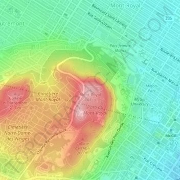
Nom : Carte topographique Mount-Royal, altitude, relief.
Altitude moyenne : 111 m
Altitude minimum : 35 m
Altitude maximum : 232 m
The hill is part of the Monteregian Hills situated between the Laurentians and the Appalachian Mountains. It gave its Latin name, Mons Regius, to the Monteregian chain. The hill consists of three peaks: Colline de la Croix (or Mont Royal proper) at 233 m (764 ft), Colline d'Outremont (or Mount Murray, in the borough of Outremont) at 211 m (692 ft), and Westmount Summit at 201 m (659 ft) elevation above mean sea level.
Autres cartes topographiques
Cliquez sur une carte pour visualiser sa topographie, son altitude et son relief.
Mount Royal Park
Canada > Quebec > Urban agglomeration of Montreal > Montreal
Mount Royal Park, Ville-Marie, Montreal, Urban agglomeration of Montreal, Montreal (administrative region), Quebec, H3G 1A8, Canada
Altitude moyenne : 110 m
Parc Marie-Claire-Kirkland-Casgrain
Canada > Quebec > Urban agglomeration of Montreal > Montreal
Parc Marie-Claire-Kirkland-Casgrain, Sault-Saint-Louis, LaSalle, Montreal, Urban agglomeration of Montreal, Montreal (06), Quebec, Canada
Altitude moyenne : 24 m
Parc-nature de la Pointe-aux-Prairies
Canada > Quebec > Urban agglomeration of Montreal > Montreal
Parc-nature de la Pointe-aux-Prairies, Rue Sherbrooke Est, Pointe-aux-Trembles, Montreal, Urban agglomeration of Montreal, Montreal (06), Quebec, H1A 3R1, Canada
Altitude moyenne : 13 m