
Faire un don
Équipez-vous pour votre prochaine aventure :
En tant que Partenaire Amazon, ce site perçoit une commission sur les achats éligibles sans surcoût pour vous.
Carte topographique Turabah
Cliquez sur la carte pour afficher l’altitude.
Faire un don
Équipez-vous pour votre prochaine aventure :
En tant que Partenaire Amazon, ce site perçoit une commission sur les achats éligibles sans surcoût pour vous.
Turabah
Turabah (Arabic: تربة, also spelled turaba, turba or tarba) is a city in Najd in Saudi Arabia, located in the valley of the same name. Turubah is located south of the mountain of Hadhn ("Jebel Hadhn"), to the southeast of Mecca. It is therefore considered on the border between the topographic regions of Hejaz and Najd. The town's traditional inhabitants are the tribe of Al-Bugum. The population of Turubah was 42,810 in 2004, while now in 2020 about 100,000.
Faire un don
Équipez-vous pour votre prochaine aventure :
En tant que Partenaire Amazon, ce site perçoit une commission sur les achats éligibles sans surcoût pour vous.
À propos de cette carte
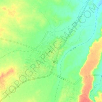
Nom : Carte topographique Turabah, altitude, relief.
Lieu : Turabah, Turubah, Makkah Region, 29751, Saudi Arabia (21.17802 41.59350 21.25802 41.67350)
Altitude moyenne : 1’161 m
Altitude minimum : 1’140 m
Altitude maximum : 1’192 m
Faire un don
Équipez-vous pour votre prochaine aventure :
En tant que Partenaire Amazon, ce site perçoit une commission sur les achats éligibles sans surcoût pour vous.
Autres cartes topographiques
Cliquez sur une carte pour visualiser sa topographie, son altitude et son relief.
Faire un don
Équipez-vous pour votre prochaine aventure :
En tant que Partenaire Amazon, ce site perçoit une commission sur les achats éligibles sans surcoût pour vous.