
Carte topographique Sayre
Carte interactive
Cliquez sur la carte pour afficher l’altitude.
À propos de cette carte
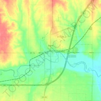
Nom : Carte topographique Sayre, altitude, relief.
Lieu : Sayre, Beckham County, Oklahoma, 73662, United States (35.24766 -99.65779 35.33907 -99.59298)
Altitude moyenne : 567 m
Altitude minimum : 537 m
Altitude maximum : 607 m
Sayre is located on the North Fork of the Red River, at an elevation of 1,800 feet (550 m) and 128 miles (206 km) west of Oklahoma City. The area is dominated by low rolling red clay hills.
Autres cartes topographiques
Cliquez sur une carte pour visualiser sa topographie, son altitude et son relief.
Texola
United States > Oklahoma > Beckham County
Texola, Beckham County, Oklahoma, 73668, United States
Altitude moyenne : 654 m
Sweetwater
United States > Oklahoma > Beckham County
Sweetwater, Beckham County, Oklahoma, 73666, United States
Altitude moyenne : 663 m
Erick
United States > Oklahoma > Beckham County
Erick, Beckham County, Oklahoma, 73645, United States
Altitude moyenne : 631 m
Sayre
United States > Oklahoma > Beckham County
Sayre, Beckham County, Oklahoma, 73662, United States
Altitude moyenne : 567 m
Sayre
United States > Oklahoma > Beckham County > Sayre > Sayre
Sayre, Beckham County, Oklahoma, 73662, United States
Altitude moyenne : 560 m
Elk City
United States > Oklahoma > Beckham County
Elk City, Beckham County, Oklahoma, United States
Altitude moyenne : 588 m