
Faire un don
Équipez-vous pour votre prochaine aventure :
En tant que Partenaire Amazon, ce site perçoit une commission sur les achats éligibles sans surcoût pour vous.
Carte topographique Lake Piru
Cliquez sur la carte pour afficher l’altitude.
Faire un don
Équipez-vous pour votre prochaine aventure :
En tant que Partenaire Amazon, ce site perçoit une commission sur les achats éligibles sans surcoût pour vous.
Lake Piru
The elevation of the reservoir is 1,043 ft (318 m), and the elevation of the dam spillway is 1,055 ft (322 m). The dam is owned and operated by the United Water Conservation District based in nearby Santa Paula, California. The district is a multi-service district providing flood control, recreation services, surface and groundwater conservation, groundwater replenishment, and wholesale water for agriculture and urban uses to the Santa Clara River Valley and Oxnard Plain. Formed on December 5, 1950, under the Water Conservation Act of 1931, it owns approximately 2,200-acre around and including the lake and dam (890 ha).
Faire un don
Équipez-vous pour votre prochaine aventure :
En tant que Partenaire Amazon, ce site perçoit une commission sur les achats éligibles sans surcoût pour vous.
À propos de cette carte
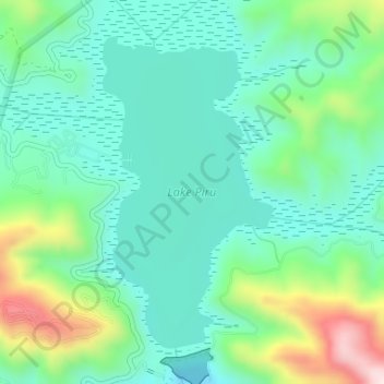
Nom : Carte topographique Lake Piru, altitude, relief.
Lieu : Lake Piru, Ventura County, California, United States (34.46173 -118.75904 34.48368 -118.74433)
Altitude moyenne : 375 m
Altitude minimum : 268 m
Altitude maximum : 664 m
Faire un don
Équipez-vous pour votre prochaine aventure :
En tant que Partenaire Amazon, ce site perçoit une commission sur les achats éligibles sans surcoût pour vous.
Autres cartes topographiques
Cliquez sur une carte pour visualiser sa topographie, son altitude et son relief.
Camarillo
United States > California > Ventura County
In the mid-1950s, the Ventura Freeway was completed from Los Angeles to points north, making it an easy one-hour trip to Camarillo. The Old Town was bisect by the Ventura Freeway. On the southern side of the freeway contains a strip of businesses, churches, schools, and parks. The freeway was originally…
Altitude moyenne : 90 m
Simi Valley
United States > California > Ventura County
Simi Valley is a city located in the very southeast corner of Ventura County, bordering the San Fernando Valley in Los Angeles County, and is a part of the Greater Los Angeles Area. The city of Simi Valley basically consists of the eponymous valley itself. The city of Simi Valley borders the Santa Susana…
Altitude moyenne : 405 m
Ojai
United States > California > Ventura County
Nordhoff Ridge, the western extension of the Topatopa Mountains, towers over the north side of the valley at more than 5,000 feet (1,500 m). Sulphur Mountain creates the southern ranges bounding the Ojai Valley, a little under 3,000 feet (910 m) in elevation. The Sulphur and Topatopa mountains are part of the…
Altitude moyenne : 289 m
Faire un don
Équipez-vous pour votre prochaine aventure :
En tant que Partenaire Amazon, ce site perçoit une commission sur les achats éligibles sans surcoût pour vous.
Simi Valley
United States > California > Ventura County
Simi Valley is a city located in the very southeast corner of Ventura County, bordering the San Fernando Valley in Los Angeles County, and is a part of the Greater Los Angeles Area. The city of Simi Valley basically consists of the eponymous valley itself. The city of Simi Valley borders the Santa Susana…
Altitude moyenne : 405 m
Faire un don
Équipez-vous pour votre prochaine aventure :
En tant que Partenaire Amazon, ce site perçoit une commission sur les achats éligibles sans surcoût pour vous.
Mount Pinos
United States > California > Ventura County
During and immediately after heavy snow storms it may not be possible to drive to the top of Mount Pinos Road due to the lack of snow plow availability. In such cases it is common for the Kern County Roads Department to close a snow gate lower on the mountain. It is still possible to ski from the snow gate and…
Altitude moyenne : 2’468 m
Faire un don
Équipez-vous pour votre prochaine aventure :
En tant que Partenaire Amazon, ce site perçoit une commission sur les achats éligibles sans surcoût pour vous.
San Nicolas Island
United States > California > Ventura County
The highest point is Jackson Hill, with an elevation of 907 feet (276 m) above sea level.
Altitude moyenne : 38 m
Ojai
United States > California > Ventura County
Nordhoff Ridge, the western extension of the Topatopa Mountains, towers over the north side of the valley at more than 5,000 feet (1,500 m). Sulphur Mountain creates the southern ranges bounding the Ojai Valley, a little under 3,000 feet (910 m) in elevation. The Sulphur and Topatopa mountains are part of the…
Altitude moyenne : 289 m
Faire un don
Équipez-vous pour votre prochaine aventure :
En tant que Partenaire Amazon, ce site perçoit une commission sur les achats éligibles sans surcoût pour vous.
Santa Paula
United States > California > Ventura County
On October 31, 2019, the Maria Fire was reported burning at the top of South Mountain between Santa Paula and Somis and expanded throughout that evening. Heavily influenced by 20–30 mph (32–48 km/h) winds within the canyons, the fire became a full scale conflagration, growing from 50 to 750 acres (20 to…
Altitude moyenne : 146 m
Thousand Oaks
United States > California > Ventura County
The northern parts consist of mountainous terrain in the Simi Hills, Conejo Mountains and Mount Clef Ridge. Narrow canyons such as Hill Canyon cut through the steeper mountainous areas. Conejo Mountain and Conejo Grade are found in westernmost Newbury Park, while the southernmost parts of Thousand Oaks are…
Altitude moyenne : 333 m
Faire un don
Équipez-vous pour votre prochaine aventure :
En tant que Partenaire Amazon, ce site perçoit une commission sur les achats éligibles sans surcoût pour vous.
Anacapa Island
United States > California > Ventura County
West Anacapa is the largest and highest islet, rising to an altitude of 930 ft (283 m) at Vela Peak, also known as Summit Peak 2. East and Middle Anacapa have fairly level areas at their tops. Middle Island reaches an altitude of 325 ft (99 m) and East Island is 250 ft (76 m) at its highest point. All three…
Altitude moyenne : 4 m
Wildwood Park
United States > California > Ventura County > Thousand Oaks
At Lizard Rock, Teepee Overlook, and similar higher elevation areas, there are panoramic views of the Conejo Valley.
Altitude moyenne : 161 m
Faire un don
Équipez-vous pour votre prochaine aventure :
En tant que Partenaire Amazon, ce site perçoit une commission sur les achats éligibles sans surcoût pour vous.
Thousand Oaks
United States > California > Ventura County
The northern parts consist of mountainous terrain in the Simi Hills, Conejo Mountains and Mount Clef Ridge. Narrow canyons such as Hill Canyon cut through the steeper mountainous areas. Conejo Mountain and Conejo Grade are found in westernmost Newbury Park, while the southernmost parts of Thousand Oaks are…
Altitude moyenne : 333 m
Faire un don
Équipez-vous pour votre prochaine aventure :
En tant que Partenaire Amazon, ce site perçoit une commission sur les achats éligibles sans surcoût pour vous.
Channel Islands Beach
United States > California > Ventura County > Silver Strand
Altitude moyenne : 3 m
Faire un don
Équipez-vous pour votre prochaine aventure :
En tant que Partenaire Amazon, ce site perçoit une commission sur les achats éligibles sans surcoût pour vous.
Newbury Park
United States > California > Ventura County > Thousand Oaks > Newbury Park
Newbury Park can be described as a town, community, or section mostly within the Thousand Oaks city limits in addition to rural areas west of Thousand Oaks. Newbury Park is bordered by Lynn Road in the east and the Conejo Grade on the west. It borders the Santa Monica Mountains in the south, while Hill Canyon…
Altitude moyenne : 262 m
Simi Valley
United States > California > Ventura County
Simi Valley is a city located in the very southeast corner of Ventura County, bordering the San Fernando Valley in Los Angeles County, and is a part of the Greater Los Angeles Area. The city of Simi Valley basically consists of the eponymous valley itself. The city of Simi Valley borders the Santa Susana…
Altitude moyenne : 405 m
Faire un don
Équipez-vous pour votre prochaine aventure :
En tant que Partenaire Amazon, ce site perçoit une commission sur les achats éligibles sans surcoût pour vous.
Jasmine Glen Estates
United States > California > Ventura County > Simi Valley
Altitude moyenne : 331 m
Santa Paula
United States > California > Ventura County
On October 31, 2019, the Maria Fire was reported burning at the top of South Mountain between Santa Paula and Somis and expanded throughout that evening. Heavily influenced by 20–30 mph (32–48 km/h) winds within the canyons, the fire became a full scale conflagration, growing from 50 to 750 acres (20 to…
Altitude moyenne : 148 m
Casitas Springs
United States > California > Ventura County > Ventura > Casitas Springs
Altitude moyenne : 182 m
Faire un don
Équipez-vous pour votre prochaine aventure :
En tant que Partenaire Amazon, ce site perçoit une commission sur les achats éligibles sans surcoût pour vous.
Greenwich Village
United States > California > Ventura County > Thousand Oaks > Greenwich Village
Altitude moyenne : 275 m