
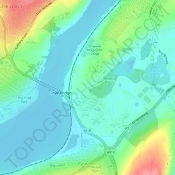
Carte topographique Gransha
Carte interactive
Cliquez sur la carte pour afficher l’altitude.
À propos de cette carte
Nom : Carte topographique Gransha, altitude, relief.
Altitude moyenne : 22 m
Altitude minimum : -2 m
Altitude maximum : 83 m
Autres cartes topographiques
Cliquez sur une carte pour visualiser sa topographie, son altitude et son relief.
Altnagelvin
United Kingdom > Northern Ireland > Londonderry/Derry
Altnagelvin, Londonderry/Derry, County Londonderry, Northern Ireland, United Kingdom
Altitude moyenne : 67 m
Clooney
United Kingdom > Northern Ireland > Londonderry/Derry
Clooney, Londonderry/Derry, County Londonderry, Northern Ireland, United Kingdom
Altitude moyenne : 39 m
Glack
United Kingdom > Northern Ireland > Londonderry/Derry
Glack, Londonderry/Derry, County Londonderry, Northern Ireland, United Kingdom
Altitude moyenne : 201 m
Coshquin
United Kingdom > Northern Ireland > Londonderry/Derry
Coshquin, Londonderry/Derry, County Londonderry, Northern Ireland, United Kingdom
Altitude moyenne : 91 m
Binevenagh
United Kingdom > Northern Ireland > Londonderry/Derry
Binevenagh, Londonderry/Derry, County Londonderry, Northern Ireland, BT49 0JB, United Kingdom
Altitude moyenne : 246 m