
Carte topographique Polk
Carte interactive
Cliquez sur la carte pour afficher l’altitude.
À propos de cette carte
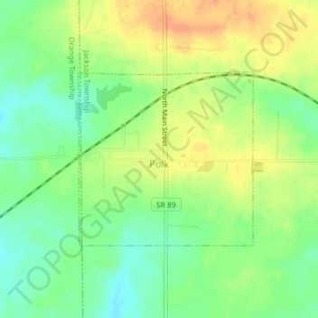
Nom : Carte topographique Polk, altitude, relief.
Lieu : Polk, Jackson Township, Ashland County, Ohio, United States (40.93756 -82.22459 40.95233 -82.20487)
Altitude moyenne : 379 m
Altitude minimum : 359 m
Altitude maximum : 400 m
Autres cartes topographiques
Cliquez sur une carte pour visualiser sa topographie, son altitude et son relief.
Rowsburg
United States > Ohio > Ashland County
Rowsburg, Perry Township, Ashland County, Ohio, United States
Altitude moyenne : 336 m
Ashland
United States > Ohio > Ashland County
Ashland, Ashland County, Ohio, United States
Altitude moyenne : 341 m
Hayesville
United States > Ohio > Ashland County
Hayesville, Vermillion Township, Ashland County, Ohio, 44838, United States
Altitude moyenne : 359 m
Cinnamon Lake
United States > Ohio > Ashland County
Cinnamon Lake, Jackson Township, Ashland County, Ohio, United States
Altitude moyenne : 360 m
Nova
United States > Ohio > Ashland County
Nova, Troy Township, Ashland County, Ohio, 44859, United States
Altitude moyenne : 345 m
Perrysville
United States > Ohio > Ashland County
Perrysville, Green Township, Ashland County, Ohio, United States
Altitude moyenne : 320 m
Sullivan
United States > Ohio > Ashland County
Sullivan, Sullivan Township, Ashland County, Ohio, 44880, United States
Altitude moyenne : 347 m
Ruggles
United States > Ohio > Ashland County
Ruggles, Ruggles Township, Ashland County, Ohio, United States
Altitude moyenne : 323 m
Savannah
United States > Ohio > Ashland County
Savannah, Clear Creek Township, Ashland County, Ohio, 44874, United States
Altitude moyenne : 327 m
Albion
United States > Ohio > Ashland County
Albion, Jackson Township, Ashland County, Ohio, 44287, United States
Altitude moyenne : 352 m
Nankin
United States > Ohio > Ashland County
Nankin, Orange Township, Ashland County, Ohio, 44848, United States
Altitude moyenne : 325 m
Bailey Lakes
United States > Ohio > Ashland County
Bailey Lakes, Clear Creek Township, Ashland County, Ohio, United States
Altitude moyenne : 326 m
Jeromesville
United States > Ohio > Ashland County
Jeromesville, Mohican Township, Ashland County, Ohio, United States
Altitude moyenne : 316 m
Vermillion Township
United States > Ohio > Ashland County
Vermillion Township, Ashland County, Ohio, 44838, United States
Altitude moyenne : 369 m
Hanover Township
United States > Ohio > Ashland County
Hanover Township, Ashland County, Ohio, 44842, United States
Altitude moyenne : 362 m
Mifflin
United States > Ohio > Ashland County
Mifflin, Mifflin Township, Ashland County, Ohio, United States
Altitude moyenne : 337 m
Loudonville
United States > Ohio > Ashland County
Loudonville, Hanover Township, Ashland County, Ohio, 44842, United States
Altitude moyenne : 328 m