
Carte topographique Killaloe Municipal District
Carte interactive
Cliquez sur la carte pour afficher l’altitude.
À propos de cette carte
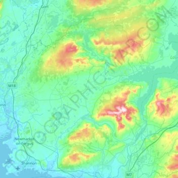
Nom : Carte topographique Killaloe Municipal District, altitude, relief.
Lieu : Killaloe Municipal District, County Clare, Munster, Ireland (52.71607 -8.95344 53.04215 -8.28242)
Altitude moyenne : 85 m
Altitude minimum : -2 m
Altitude maximum : 530 m
Autres cartes topographiques
Cliquez sur une carte pour visualiser sa topographie, son altitude et son relief.
Clooney
Clooney, Killaloe Municipal District, County Clare, Munster, Ireland
Altitude moyenne : 57 m
Lahinch
Lahinch, Ennistimon ED, West Clare Municipal District, County Clare, Munster, Ireland
Altitude moyenne : 35 m
Doonbeg
Doonbeg, West Clare Municipal District, County Clare, Munster, Ireland
Altitude moyenne : 11 m
Turlough Hill
Turlough Hill, West Clare Municipal District, County Clare, Munster, H91 K526, Ireland
Altitude moyenne : 129 m
Kilmihil
Kilmihil, West Clare Municipal District, County Clare, Munster, Ireland
Altitude moyenne : 69 m
Connolly
Connolly, Kinturk ED, West Clare Municipal District, County Clare, Munster, Ireland
Altitude moyenne : 96 m
Mountallon
Mountallon, Kyle ED, Killaloe Municipal District, County Clare, Munster, Ireland
Altitude moyenne : 32 m
Corkscrew Hill
Corkscrew Hill, Rathborney ED, West Clare Municipal District, County Clare, Munster, H91 CF60, Ireland
Altitude moyenne : 168 m
Corofin
Corofin, Corrofin ED, West Clare Municipal District, County Clare, Munster, Ireland
Altitude moyenne : 24 m
Kilfenora
Kilfenora, Kilfenora ED, West Clare Municipal District, County Clare, Munster, Ireland
Altitude moyenne : 70 m
Doonass
Doonass, Kiltenanlea ED, Shannon Municipal District, County Clare, Munster, Ireland
Altitude moyenne : 28 m
Shannon Municipal District
Shannon Municipal District, County Clare, Munster, Ireland
Altitude moyenne : 35 m
Black Head (Clare)
Black Head (Clare), R477, Gleninagh ED, West Clare Municipal District, County Clare, Munster, Ireland
Altitude moyenne : 40 m
Ballyea North
Ballyea North, Ballyea ED, West Clare Municipal District, County Clare, Munster, Ireland
Altitude moyenne : 70 m
Kilrush
Kilrush, Kilrush Urban ED, West Clare Municipal District, County Clare, Munster, Ireland
Altitude moyenne : 24 m
Letterkelly
Letterkelly, Cloonanaha ED, West Clare Municipal District, County Clare, Munster, Ireland
Altitude moyenne : 193 m
West Clare Municipal District
West Clare Municipal District, County Clare, Munster, Ireland
Altitude moyenne : 37 m
Ennis Municipal District
Ennis Municipal District, County Clare, Munster, Ireland
Altitude moyenne : 39 m
Island
Island, Mountievers ED, Shannon Municipal District, County Clare, Munster, Ireland
Altitude moyenne : 90 m
Oughterard
Oughterard, Kilballyowen ED, West Clare Municipal District, County Clare, Munster, Ireland
Altitude moyenne : 26 m
Killaloe
Ireland > County Clare > Killaloe
Killaloe, Killaloe ED, Killaloe Municipal District, County Clare, Munster, Ireland
Altitude moyenne : 58 m
Moybeg
Moybeg, Moy ED, West Clare Municipal District, County Clare, Munster, Ireland
Altitude moyenne : 53 m
Carrigaholt
Carrigaholt, Rahona ED, West Clare Municipal District, County Clare, Munster, Ireland
Altitude moyenne : 11 m
Broadford
Broadford, Kilseily ED, Killaloe Municipal District, County Clare, Munster, Ireland
Altitude moyenne : 95 m
Kilmoon
Kilmoon, West Clare Municipal District, County Clare, Munster, V95 T85K, Ireland
Altitude moyenne : 157 m
Miltown Malbay
Ireland > County Clare > Miltown Malbay
Miltown Malbay, West Clare Municipal District, County Clare, Munster, V95 V9Y8, Ireland
Altitude moyenne : 46 m
Ballynagun West
Ballynagun West, Drumellihy ED, West Clare Municipal District, County Clare, Munster, Ireland
Altitude moyenne : 31 m
Quin
Quin, Killaloe Municipal District, County Clare, Munster, Ireland
Altitude moyenne : 27 m
Liscannor
Liscannor, Liscannor ED, West Clare Municipal District, County Clare, Munster, Ireland
Altitude moyenne : 12 m
Corofin
Ireland > County Clare > Corofin
Corofin, West Clare Municipal District, County Clare, Munster, Ireland
Altitude moyenne : 25 m