Géolocaliser

Carte topographique Aluva

Carte interactive

Cliquez sur la carte pour afficher l’altitude.

À propos de cette carte

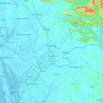
Nom : Carte topographique Aluva, altitude, relief.

Lieu : Aluva, Ernakulam District, Kerala, Inde (10.03721 76.31146 10.30322 76.68730)

Altitude moyenne : 34 m

Altitude minimum : -4 m

Altitude maximum : 690 m

Autres cartes topographiques

Cliquez sur une carte pour visualiser sa topographie, son altitude et son relief.

Poovar

Inde > Kerala > Poovar

Poovar, Neyyattinkara, Thiruvananthapuram, Kerala, 695525, Inde

Altitude moyenne : 12 m

Thiruvananthapuram

Inde > Kerala > Thiruvananthapuram

Thiruvananthapuram, Kerala, 695001, Inde

Altitude moyenne : 38 m

Kochi

Inde > Kerala > Kochi

Kochi, Ernakulam, Kerala, 628002, Inde

Altitude moyenne : 4 m

Pulloor

Inde > Kerala > Pulloor

Pulloor, Thrissur, Kerala, 680683, Inde

Altitude moyenne : 8 m