
Carte topographique Zacatecas City
Carte interactive
Cliquez sur la carte pour afficher l’altitude.
À propos de cette carte
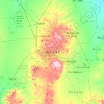
Nom : Carte topographique Zacatecas City, altitude, relief.
Altitude moyenne : 2’290 m
Altitude minimum : 2’062 m
Altitude maximum : 2’732 m
The municipality is wedged between the Sierra Madre Occidental and the subrange called Sierras y Valles Zacatecanos. The area is very rugged terrain filled with narrow valleys, ravines and mountains. The principal elevations include Cerro El Grillo at 2,690 m (8,830 ft), Cerro Los Alamitos at 2,680 m (8,790 ft), Cerro La Bufa at 2,650 m (8,690 ft), Cerro La Mesa at 2,590 m (8,500 ft), Mesas El Rincón Colorado at 2,540 m (8,330 ft), Cerro La Mesa at 2,440 m (8,010 ft) and Cerro Grande at 2,370 m (7,780 ft). The area is divided between the Lerma River and El Salado River basins, with a large number of small streams and arroyos crossing the territory.