
Carte topographique Lake Water Wheel
Carte interactive
Cliquez sur la carte pour afficher l’altitude.
À propos de cette carte
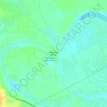
Nom : Carte topographique Lake Water Wheel, altitude, relief.
Lieu : Lake Water Wheel, San Jacinto County, Texas, United States (30.45215 -94.93049 30.49215 -94.89049)
Altitude moyenne : 23 m
Altitude minimum : 14 m
Altitude maximum : 46 m
Autres cartes topographiques
Cliquez sur une carte pour visualiser sa topographie, son altitude et son relief.
Point Blank
United States > Texas > San Jacinto County
Point Blank, San Jacinto County, Texas, United States
Altitude moyenne : 54 m
Coldspring
United States > Texas > San Jacinto County
Coldspring, San Jacinto County, Texas, United States
Altitude moyenne : 103 m
Shepherd
United States > Texas > San Jacinto County
Shepherd, San Jacinto County, Texas, 77371, United States
Altitude moyenne : 45 m
Pointblank
United States > Texas > San Jacinto County > Point Blank > Pointblank
Pointblank, Point Blank, San Jacinto County, Texas, 77364, United States
Altitude moyenne : 53 m
Maynard
United States > Texas > San Jacinto County > Maynard
Maynard, San Jacinto County, Texas, United States
Altitude moyenne : 114 m