
Carte topographique Izeh
Carte interactive
Cliquez sur la carte pour afficher l’altitude.
À propos de cette carte
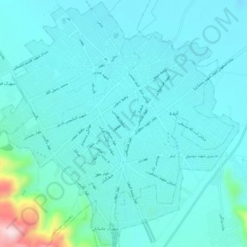
Nom : Carte topographique Izeh, altitude, relief.
Lieu : Izeh, بخش مرکزی, Izeh County, Khuzestan Province, Iran (31.80775 49.84117 31.85090 49.89254)
Altitude moyenne : 862 m
Altitude minimum : 811 m
Altitude maximum : 1’205 m
Autres cartes topographiques
Cliquez sur une carte pour visualiser sa topographie, son altitude et son relief.
Izeh
Iran > Khuzestan Province > Izeh County > دهستان حومه غربی
Izeh, دهستان حومه غربی, بخش مرکزی, Izeh County, Khuzestan Province, Iran
Altitude moyenne : 889 m
عالی
Iran > Khuzestan Province > Izeh County > دهستان حومه شرقی > عالی
عالی, دهستان حومه شرقی, بخش مرکزی, Izeh County, Khuzestan Province, Iran
Altitude moyenne : 1’272 m