
Carte topographique Hot Springs
Carte interactive
Cliquez sur la carte pour afficher l’altitude.
À propos de cette carte
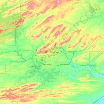
Nom : Carte topographique Hot Springs, altitude, relief.
Lieu : Hot Springs, Garland County, Arkansas, 71901, United States (34.34384 -93.21524 34.66384 -92.89524)
Altitude moyenne : 187 m
Altitude minimum : 66 m
Altitude maximum : 419 m
Autres cartes topographiques
Cliquez sur une carte pour visualiser sa topographie, son altitude et son relief.
Hot Springs National Park
United States > Arkansas > Garland County > Hot Springs
Hot Springs National Park, Hot Springs, Garland County, Arkansas, 71901, United States
Altitude moyenne : 227 m
Piney
United States > Arkansas > Garland County > Hot Springs
Piney, Hot Springs, Garland County, Arkansas, United States
Altitude moyenne : 146 m
Lake Hamilton
United States > Arkansas > Garland County > Hot Springs
Lake Hamilton, Hot Springs, Garland County, Arkansas, United States
Altitude moyenne : 130 m