
Carte topographique Clarksville
Carte interactive
Cliquez sur la carte pour afficher l’altitude.
À propos de cette carte
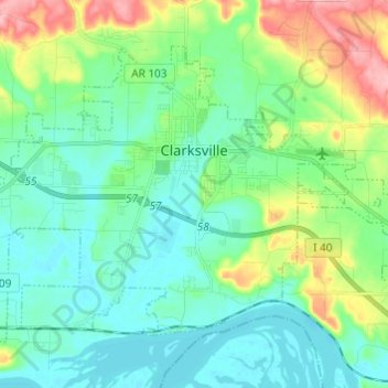
Nom : Carte topographique Clarksville, altitude, relief.
Lieu : Clarksville, Johnson County, Arkansas, 72830, United States (35.42239 -93.53741 35.49780 -93.41600)
Altitude moyenne : 137 m
Altitude minimum : 102 m
Altitude maximum : 238 m
Spadra was the first county seat of Johnson County, convenient to steamboat lines. However when stagecoach and train transportation became more common, land routes from Little Rock to Fort Smith were directed along higher elevations through Clarksville. As Clarksville grew, it became the de facto location for the county seat circa 1833, probably due to severe flooding at Spadra. Clarksville was established by survey in November 1836 after Johnson County was formed from part of Pope County. The first court session was held in 1837 in a private building.
Autres cartes topographiques
Cliquez sur une carte pour visualiser sa topographie, son altitude et son relief.
Coal Hill
United States > Arkansas > Johnson County
Coal Hill, Johnson County, Arkansas, 72832, United States
Altitude moyenne : 163 m
Montana
United States > Arkansas > Johnson County
Montana, Johnson County, Arkansas, United States
Altitude moyenne : 125 m
Harmony
United States > Arkansas > Johnson County
Harmony, Johnson County, Arkansas, United States
Altitude moyenne : 206 m
Knoxville
United States > Arkansas > Johnson County
Knoxville, Johnson County, Arkansas, 72845, United States
Altitude moyenne : 128 m
Sulphur Springs
United States > Arkansas > Johnson County
Sulphur Springs, Johnson County, Arkansas, United States
Altitude moyenne : 163 m
Hickeytown
United States > Arkansas > Johnson County
Hickeytown, Johnson County, Arkansas, United States
Altitude moyenne : 140 m
Gillian Settlement
United States > Arkansas > Johnson County
Gillian Settlement, Johnson County, Arkansas, United States
Altitude moyenne : 481 m
Oark
United States > Arkansas > Johnson County
Oark, Johnson County, Arkansas, United States
Altitude moyenne : 389 m
Hagarville
United States > Arkansas > Johnson County
Hagarville, Johnson County, Arkansas, United States
Altitude moyenne : 173 m
Hartman
United States > Arkansas > Johnson County
Hartman, Johnson County, Arkansas, United States
Altitude moyenne : 126 m
Lake Dardanelle
United States > Arkansas > Johnson County > Knoxville
Lake Dardanelle, Knoxville, Johnson County, Arkansas, 72845, United States
Altitude moyenne : 176 m
Lamar
United States > Arkansas > Johnson County
Lamar, Johnson County, Arkansas, United States
Altitude moyenne : 139 m
Ozone
United States > Arkansas > Johnson County
Ozone, Johnson County, Arkansas, 72854, United States
Altitude moyenne : 537 m
Strawberry
United States > Arkansas > Johnson County
Strawberry, Johnson County, Arkansas, United States
Altitude moyenne : 245 m