
Carte topographique Grapeview
Carte interactive
Cliquez sur la carte pour afficher l’altitude.
À propos de cette carte
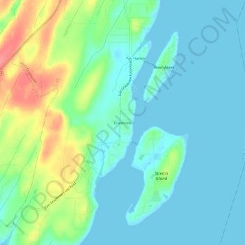
Nom : Carte topographique Grapeview, altitude, relief.
Lieu : Grapeview, Mason County, Washington, United States (47.31176 -122.85514 47.35176 -122.81514)
Altitude moyenne : 21 m
Altitude minimum : 0 m
Altitude maximum : 81 m
Autres cartes topographiques
Cliquez sur une carte pour visualiser sa topographie, son altitude et son relief.
Matlock
United States > Washington > Mason County
Matlock, Mason County, Washington, 98560, United States
Altitude moyenne : 133 m
Triton
United States > Washington > Mason County
Triton, Mason County, Washington, United States
Altitude moyenne : 122 m
Belfair
United States > Washington > Mason County
Belfair, Mason County, Washington, United States
Altitude moyenne : 63 m
Shelton
United States > Washington > Mason County
Shelton, Mason County, Washington, United States
Altitude moyenne : 54 m
Harstine Island
United States > Washington > Mason County
Harstine Island, Mason County, Washington, United States
Altitude moyenne : 30 m
Lake Cushman
United States > Washington > Mason County
Lake Cushman, Mason County, Washington, United States
Altitude moyenne : 406 m
Lake Kokanee
United States > Washington > Mason County
Lake Kokanee, Mason County, Washington, United States
Altitude moyenne : 215 m
Lake Wooten
United States > Washington > Mason County
Lake Wooten, Mason County, Washington, United States
Altitude moyenne : 130 m
Allyn
United States > Washington > Mason County
Allyn, Mason County, Washington, 98524, United States
Altitude moyenne : 45 m
Hoodsport
United States > Washington > Mason County
Hoodsport, Mason County, Washington, 98548, United States
Altitude moyenne : 62 m
Shelton
United States > Washington > Mason County > Shelton > Shelton
Shelton, Mason County, Washington, United States
Altitude moyenne : 55 m
Lilliwaup
United States > Washington > Mason County > Lilliwaup
Lilliwaup, Mason County, Washington, United States
Altitude moyenne : 114 m
Tahuya
United States > Washington > Mason County
Tahuya, Mason County, Washington, 98588, United States
Altitude moyenne : 49 m